South German Scarplands
Süddeutsche Schichtstufenlandschaft
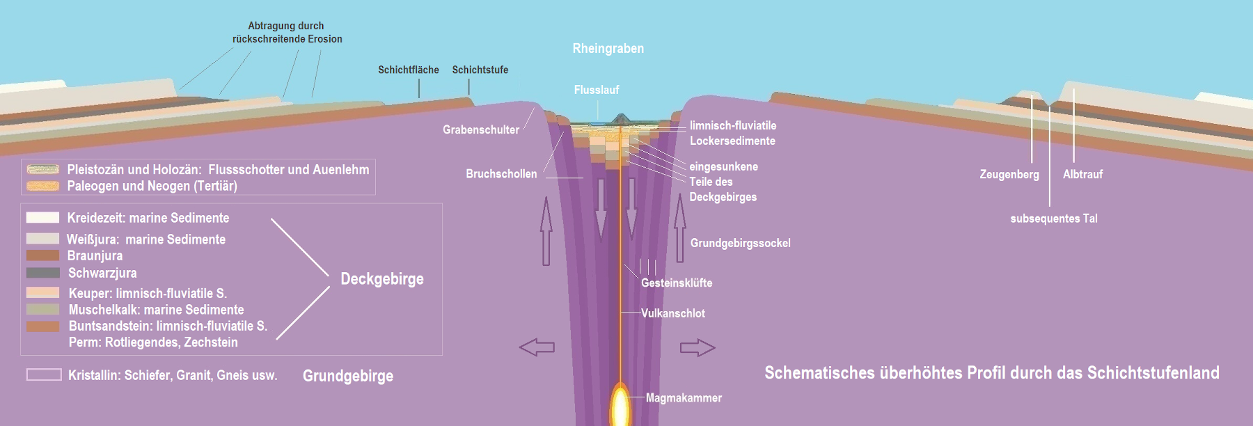
The term Süddeutsche Schichtstufenlandschaft (South German Scarplands) usually refers to the area from the Main River to the southern edge of the Swabian Alb, the Danube River, and from the Rhine Rift Valley to the eastern edge of the Franconian Jura. In fact, however, it is somewhat larger; on the western side of the Rhine valley, the structure continues in mirror image.
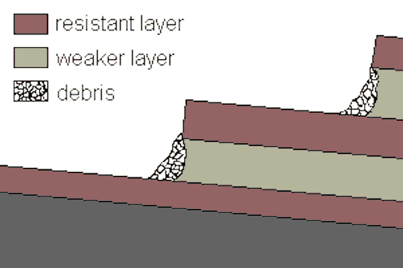
Due to its geological structure, this landscape has a succession of escarpments aka cuestas of different heights. In morphological terms, escarpments are two levels that are at different sea levels and are separated by a steep slope, often with almost vertical rock faces or cliffs. These cliff-like rocks are called escarpment face. Such structures are very common in sedimentary rocks because they are practically inevitable due to the different hardness of the layers. Hard, weathering-resistant layers resist weathering well, which is why the underlying, less hard layers are usually removed first. However, if the hard layer loses its foundation, the protruding part breaks off. In other words, the step weathers at its front and therefore moves slowly into the plateau, this is called retrograde weathering.
The question arises as to why there are so many layered steps in this area in particular, which virtually form a "staircase". The reason is quite simple, and again not really rare: a package of Mesozoic sediments becomes an anticline through uplift. In the case of the South German Scarplands, this is the uplift in the area of the Rhine Graben, which raised the crystalline of the Black Forest and the Vosges. In addition, the lowering of the Rhine valley was the starting point for weathering. As a result, starting from the Rhine valley, a cuesta formed which then "migrated away", then the next and so on.
The uplift of the strata occurred in the Pliocene. Since then, they have been shifting further and further to the east or southeast as a result of progressive weathering. The Jurassic cuesta, the Swabian Alb and Franconian Alb, formed as early as the Tertiary or Cretaceous period. The retreat of the Alb ridge is proven by "witness" mountains, remnants of the former plateau, which stand in front of the escarpment and thus indicate how far the step used to extend at least. The most famous witness mountains are the Hohenzollern near Hechingen, the Achalm near Reutlingen, the three Kaiserberge (imperial mountains) Staufen, Stuifen and Rechberg and the Ipf near Bopfingen.
Now it also becomes clear why the stratified landscape continues mirror-inverted on the other side of the Rhine valley. The same rocks and the same tectonics resulted in the same morphology. Because of the proximity to the French border, part of it is in France, but there is also an area within Germany that we group together on showcaves.com because of the same geological structure. The area is called Pfälzisch-Saarländisches Schichtstufenland or Nordfranzösisches Schichtstufenland (Northern French Scarplands). On the French side, the structures are less clear, but we have nevertheless added the German part of the area to the Southern German stratified landscape.
| Cap Rock | South German Scarplands | Palatinate-Saarland Scarplands |
|---|---|---|
| Buntsandstein |
 Spessart
Odenwald Spessart
Odenwald
|
Pfälzer Bergland |
| Muschelkalk | Schwäbisch-Fränkische Gäue |
Lorraine Trias-Lias Land |
| Schilfsandstein (Keuper) | Keuper-Lias Plains |
Lorraine Trias-Lias Land |
| Kieselsandstein (Keuper) | Virngrund, Keuper-Lias Plains |
Lorraine Trias-Lias Land |
| Stubensandstein (Keuper) | Schönbuch, Keuper-Lias Plains |
Lorraine Trias-Lias Land |
| Unterer Lias | Filderebene, Keuper-Lias Plains |
Lorraine Trias-Lias Land |
| Eisensandstein (Dogger) | very small escarpment, at the foot of the Schwäbische Alb escarpmepn | |
| Massenkalk (Malm) |
Fränkische Alb
Schwäbische Alb
|
Lorraine Jura |
The hard layers which form the surface of the plateaus and the escarpments are called cap rock. The slightly dipping plateau is called dip slope, the escarpment is also called scarp slope. The plateaus which consist of soluble rock are subject to karstification and generally have caves. The most spectacular are the Malm (Upper Jurassic) plateaus of the Swabian and Franconian Alb, and the Muschelkalk plains.
- Pfälzer Bergland
- Spessart
- Odenwald
- Schwäbisch-Fränkische Gäue
- Keuper-Lias Plains
- Fränkische Alb
- Schwäbische Alb
 Search DuckDuckGo for "South German Scarplands"
 South German Scarplands - Wikipedia (visited: 22-JAN-2022)
 Index
Index Topics
 Hierarchical
 Countries
 Maps
Maps