Tiankeng
Tiankeng is a term which was coined in October 2001 by Zhu Xuewen from the China Cave Study Association and Institute of Karst Geology in Guilin, to have a name for this exceptional subgroup of dolines. A doline has to be at least 100 m deep and 100 m in diameter to qualify. Some 75 of those huge dolines are known worldwide, 50 of them are located in China. The rest are found in tropical countries like Papua New Guinea, Malaysia, and Mexico. Tiankeng translates from Chinese as "heavenly pit" or "sky hole" and is the term which is commonly used in Guilin for this huge dolines.
We have only the biggest of all Tiankengs listed from China, despite the abundance of such dolines there. Unfortunately there is little published about them, probably because they are so common, and most publications are in Chinese. However, there are such huge dollines all over the world and we tried to list the most impressive ones, especially those which are of touristic interest.
Examples
| Name | ⌀max | ⌀min | Depth | Country | Location | kmz | Comment |
|---|---|---|---|---|---|---|---|
| List of famous Tiankengs | |||||||
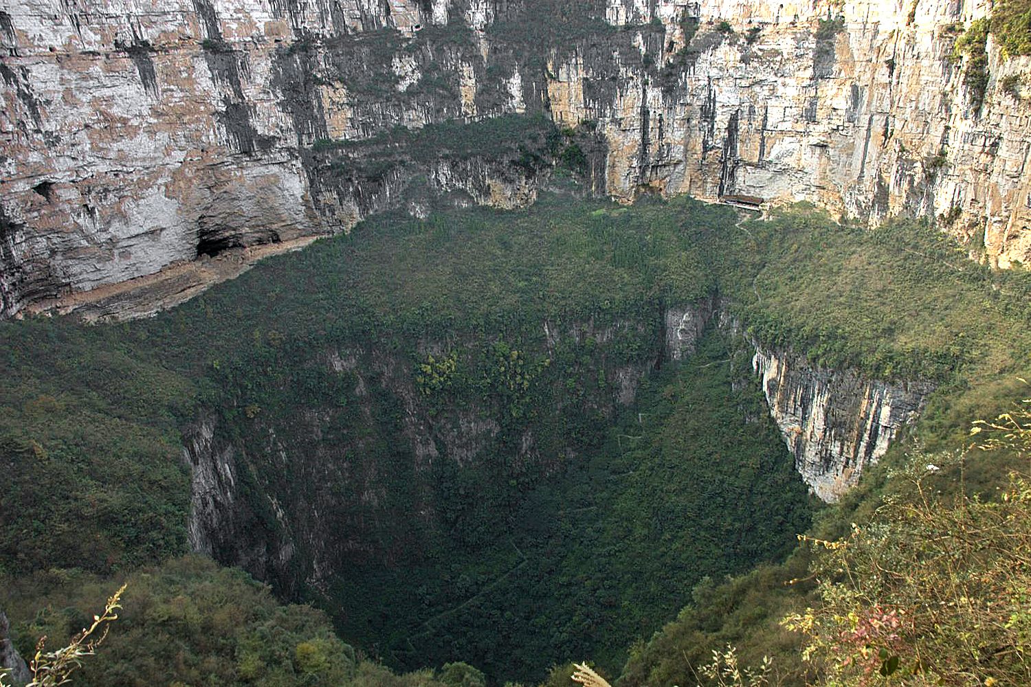
 Xiaozhai Tiankeng Xiaozhai Tiankeng |
626 m | 537 m | 662 m | China | Chongqing |  location location |
definitely the deepest sinkhole |
| Crveno Jezero |
475 m | 420 m | 530 m | Croatia | Dalmatia | location |
less than half visible, bottom half filled with water |
| Minyé Sinkhole | 350 m | 350 m | 510 m | Papua New Guinea | New Britain, Nakanaï Mountains | location |
5,421 m long cave at the bottom |
| Hranická propast |
104 m | 34 m | 473 m | Czech Republic | Olomoucký kraj | location |
vast discoveries in the last years |
| Pozzo del Merro |
35 m | 35 m | 392 m | Italy | Lazio | location |
deepest water filled sinkhole |
| Sima Aonda |
160 m | 120 m | 383 m | Venezuela | Auyan Tepui | location |
in quartzite |
 Sótano de las Golondrinas Sótano de las Golondrinas |
305 m | 135 m | 376 m | México | San Luis Potosí | location |
pretty famous with cavers |
| Cenote Zacatón |
116 m | 116 m | 339 m | México | Tamaulipas | location |
second-deepest water filled sinkhole |
| Sima Humboldt - Sima Major |
352 m | 245 m | 314 m | Venezuela | Sarisariñama tepui | location |
in quartzite |
| Naré sinkhole | 150 m | 120 m | 310 m | Papua New Guinea | New Britain, Nakanaï Mountains | location |
At the bottom Vaisseau Fantôme river (Flying Dutchman river), L=2,000 m |
| Modro Jezero | 700 m | 400 m | 290 m | Croatia | Dalmatia | location |
Neighbour of Crveno Jezero, see there. |
| Teeq |
1,000 m | 750 m | 250 m | Oman | Dhofar Governorate | location |
bowl-like shape but really huge |
| Sima Martel - Sima Menor |
155 m | 110 m | 248 m | Venezuela | Sarisariñama tepui | location |
in quartzite |
| Tawi Ateer |
130 m | 90 m | 210 m | Oman | Dhofar Governorate | location |
steep walls |
| Velika Dolina | 300 m | 170 m | 155 m | Slovenia | Primorska | location |
The entrance to the
 Skocjanske Jame (Skocjan Caves)
is the Great Doline. Skocjanske Jame (Skocjan Caves)
is the Great Doline.
|
| Caverna Janelão: Northern Doline |
500 m | 220 m | 150 m | Brazil | Minas Gerais | location |
|
| Caverna Janelão: Southern Doline |
490 m | 180 m | 150 m | Brazil | Minas Gerais | location |
|
| Parque Las Cavernas del Río Camuy: Sumidero Tres Pueblos |
185 m | 145 m | 125 m | Puerto Rico | Río Camuy | location |
|
| La dolina Pozzatina |
640 m | 380 m | 100 m | Italy | Puglia | location |
the hugest doline you can see in Europe |
| Pulicchio di Gravina |
530 m | 400 m | 100 m | Italy | Puglia | location |
|
| Zhenxiong Tiankeng |
600 m | 300 m | 200 m | China | Yunnan Province | location |
The Daguoquan sinkhole cluster, also called Zhenxiong sinkhole cluster, is a group of six tiankengs in Zhenxiong County. This is the largest with a hamlet inside which lives of farming on the floor. |
Literature
- Zhu Xuewen, Chen Weihai (2006): Tiankengs in the karst of China, Speleogenesis and Evolution of Karst Aquifers, Issue 9, 2006, Tiankengs. researchgate
- Tony Waltham (2006): The 2005 Tiankeng Investigation Project in China, Speleogenesis and Evolution of Karst Aquifers, 2006, 4 (1), The Online Scientific Journal, ISSN 1814-294X. academia.edu
- Tony Waltham (2006): Tiankengs of the world, outside China, CAVE AND KARST SCIENCE Vol. 32, No. 2 & 3, 2005, Transactions of the British Cave Research Association, ISSN 1356-191X. academia.edu
- Arthur Palmer, Margaret V. Palmer (2006): Hydraulic processes in the origin of tiankengs, Speleogenesis and Evolution of Karst Aquifers, 2006, 4 (1), The Online Scientific Journal, ISSN 1814-294X. academia.edu
- Tony Waltham (2006): Collapse processes at the tiankengs of Xingwen, Speleogenesis and Evolution of Karst Aquifers, 2006, 4 (1), The Online Scientific Journal, ISSN 1814-294X. academia.edu
 Search DuckDuckGo for "Tiankeng"
 China Keeps Finding Massive Sinkholes Teeming With Strange Wildlife (visited: 09-JAN-2025)
 Index
Index Topics
 Hierarchical
 Countries
 Maps
Maps