Alps

The Alps are a high mountain area which started to lift in the late Tertiary, 10 Million years ago. This lift happened in distinct uplifts with longer periods of relaxation. At the beginning of the Pleistocene, 1.5 Million years ago, the Alps were already formed.
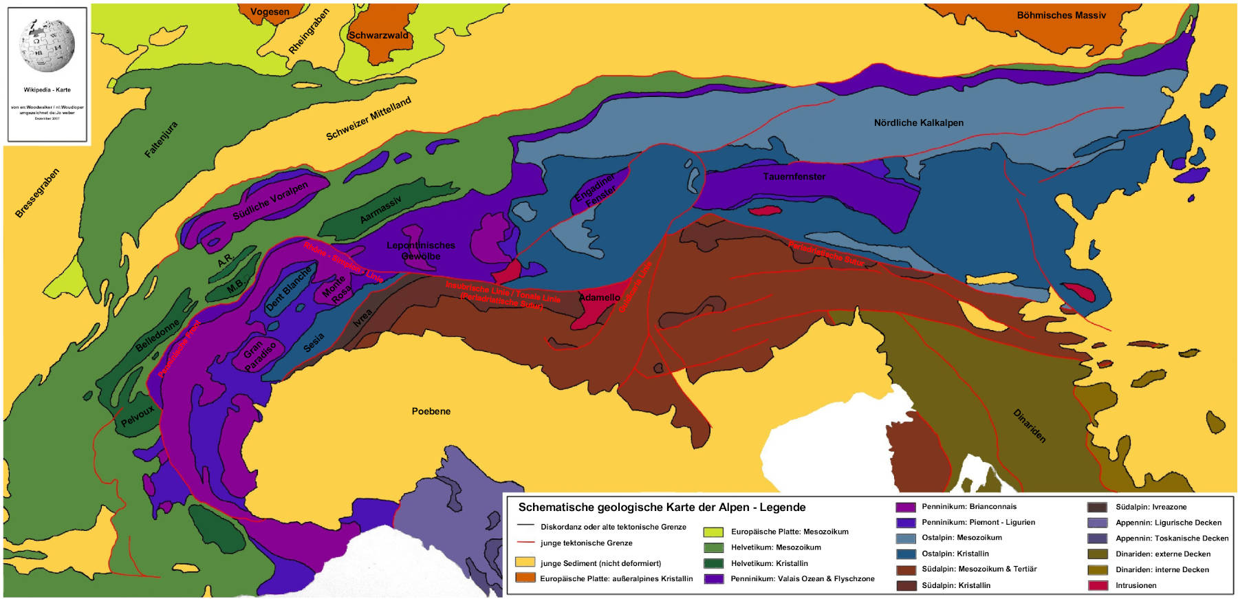
The rocks of the Alps were deposited in the last 200 Million years in the alpine geosyncline This syncline consisted of several parts. The northern limestone Alps consist of limestone from one of those parts, called Kalkalpen-Trog (Limestone Alps Basin).
Most of the Alps belongs to Switzerland, Austria, France and Italy. The German part of the Alps is just a small area along the southern border of Germany, less than 30 km wide, extending from Lake Konstanz to Salzburg. The highest mountains in this area and the highest mountain of Germany is the Zugspitze with 2963 m asl.
The German part of the Alps is separated into three parts:
- Allgäuer Alpen between Bodensee (Lake Konstanz) and river Lech.
- Karwendel Gebirge with Ammergauer Berge and Wetterstein around Garmisch-Partenkirchen and Mittenwald.
- Berchtesgadener Alpen and the Wendelstein near Berchtesgaden.
The rock sequence in the Alps starts with limestone rich layers of the middle Triassic. Very important for the Morphology, but also for karstification, is a layer called Wettersteinkalk. This is reef limestone, often secondarily dolomitized. The next layers are marls and limestones form the Jurassic and Cretaceous. The Cretaceous ends with breccias and conglomerates.
A specialty of the German Alps is the almost complete missing of any volcanic rocks. There are almost no resources and no mines. In the Allgäuer Alpen and the Bayerische Alpen the limestone is quarried as ashlars or building blocks. Near Bad Reichenhall and Berchtesgaden rock salt is mined. It is found in the oldest layers of the German Alps which are from the Upper Permian.
For speleology in the northern limestone Alps, the climate is of great importance. While caves in Germany generally have a temperature between 8 °C and 10 °C, the alpine caves have a much lower temperature, depending on the height above sea level. Cave temperature is generally the long time average temperature of the outside. The low temperatures make it unlikely the caves developed at their current elevation, or at least they developed during an era when the climate was much warmer.
Another special thing are caves with a temperature around 0 °C, the freezing point of water. Water entering the cave freezes inside the cave and creates ice layers, glaciers, ice stalactites and stalagmites. If the summer rises the temperature a part of the ice melts during summer and the form of the ice changes every year. If the ice does not melt during summer, the cave may fill completely with ice.
- Sights of This Region
 Almbachklamm
 Alte Saline
 Bärenhöhle Oberammergau
- Erlebnisbergwerk Berchtesgaden
- Heilstollen Berchtesgaden
- Breitachklamm
- Eisenbreche Klamm
- Eiskapelle
 Funtensee
- Gießenbachklamm
- Gottesackerplateau
- Erlebniswelt am Grünten
- Höllentalklamm
 Kuhfluchtwasserfälle
- Luegstein Höhle
 Dokumentation Obersalzberg
- Partnachklamm
 Schellenberg Ice Cave
- Starzlachklamm
- Sturmann Cave (Sturmartzloch)
- Weber an der Wand
- Wendelstein Cave
- Wimbachklamm
 Search DuckDuckGo for "Alps"
 Alps - Wikipedia
 Index
Index Topics
 Hierarchical
 Countries
 Maps
Maps