Höhlenburg Fracstein
Grottenburg Fracstein
Useful Information
| Location: |
Burg Fracstein, 7212 Seewis im Prättigau.
Seewis im Prättigau, at the road between Grüsch and Landquart. A Zürich-St. Gallen exit Landquart, follow main road towards Davos, turn off at campground or behind the tunnel and follow old road through the gorge. (46.9757359, 9.6158211) |
| Open: |
no restrictions. [2024] |
| Fee: |
free. [2024] |
| Classification: |
 Cave Castle Cave Castle
|
| Light: | none, not necessary |
| Dimension: | A=640 m asl. |
| Guided tours: | self guided |
| Photography: | allowed |
| Accessibility: | no |
| Bibliography: |
Maria-Letizia Boscardin (1977): Die Grottenburg Fracstein und ihre Ritzzeichnungen, Schweizer Beiträge zur Kulturgeschichte und Archäologie des Mittelalters, Bd. 4. Olten 1977. O. P. Clavadetscher, W. Meyer (1984): Grottenburg Fracstein, Das Burgenbuch von Graubünden, 1984, 330-338 Maria-Letizia Boscardin, Werner Meyer (2023): Burgenforschung in Graubünden: Berichte über die Forschungen auf den Burgruinen Fracstein und Schiedberg Heidelberg: Propylaeum, 2023 (Schweizer Beiträge zur Kulturgeschichte und Archäologie des Mittelalters, Band 4). Die Printausgabe erschien 1977 beim Walter-Verlag, Olten, ISBN 978-3-530-09540-1. pdf DOI |
| Address: | Burg Fracstein, 7212 Seewis im Prättigau. |
| As far as we know this information was accurate when it was published (see years in brackets), but may have changed since then. Please check rates and details directly with the companies in question if you need more recent info. |
|
History
| 12th century | castle probably built by the Lords of von Aspermont. |
| 1338 | first mentioned in the treaty as it was sold to the Count Friedrich V. von Toggenburg. |
| 1436 | with the death of Frederick VII, the last Count of Toggenburg, Fracstein passed to the Knights of Matsch. |
| 1466 | sold to the Austrian empire which abandoned the castle. |
| 1530 | church abandoned. |
| 1570 | castle ruined. |
| 1621 | dam renovated by Oberst Alois Baldiron. |
| 1622 | a small Austrian army unit is stationed at the castle, but is chased away by the locals. |
| 1649 | Prättigau becomes independent and the castle ruine is now owned by the village Schiers. |
| 1799 | the Bündner Landsturm tried to stop the French invasion here, but failed. |
| 19th century | further destruction by the construction of the railroad and the modern road. Ruin used as a quarry. |
Description


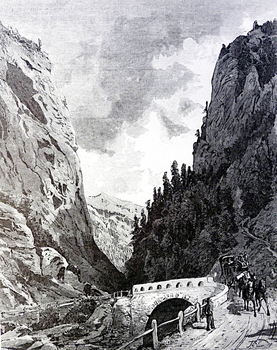
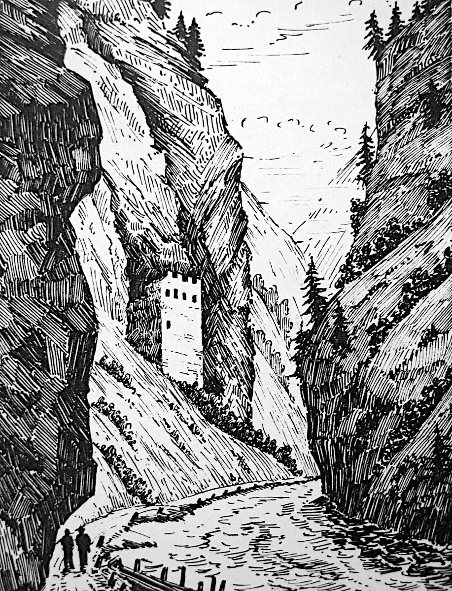
The Grottenburg Fracstein (cave castle Fracstein) is located in an extremely prominent place, in the gorge called Klus, the entrance to the Prättigau. This castle with its dam was able to protect the access to the Prättigau through this narrow gorge. The main stronghold once had four storeys and was surrounded by a wall called Letzi. The entrance was originally in the second floor, while the third was the inhabited floor, the living quarters. Please note that this is the Swiss method of counting, where the ground floor is counted as 0, not the American method.
There was also the church St. Aper and the house of the Burgpfaffen (castle priest) a little down the valley. The church was first mentioned in 1370 and last mentioned in 1520. Today, only a part of the foundations still exist. At the river Landquart below was a toll station. Both were connected by a wall.
The most impressive sight of this ruin are the gravures from the 13th century. They are located in the plastering inside the residential building, in the former third floor. The gravures show various castles with wooden constructions, palisades and the coats of arms of local knights. The most important ones are today in the Rhätisches Museum in Chur.
There is little known about the origin of the name. In itself, the obvious interpretation would be the lating origin: saxa fracta (broken rock) would fit the location of the castle at the foot of a vertical rock face. In documents, however, the name appears four times as Fragenstein, first in 1338 and last in 1509 and earlier in 1344, the castle is mentioned once as ze Fragstein. There is no really good interpretation of the name. One is the verb vragen which means to question and could be a reference on the toll station. But more likely is Ragensein where ragen means to protrude and is obviously a description of the cliff above.
To reach the castle is a bit tricky.
The narrow gorge is a main route to Davos and the new
 Vereina Tunnel
at Klosters, so traffic is rather heavy, and there is no parking possibility.
A new tunnel was built to avoid the gorge completely, but the old road through the gorge still exists.
It is used only by inline skaters and bicyclists now.
You may switch to this road on both ends of the gorge, but while you just follow the white sign to Landquart at the first turnoff east of the tunnel, it is hard to find the small single lane track on the western side.
There is a small turnoff soon after Landquart, about 200 m before the big gas station, which is signposted with a camping symbol, then turn right on a single track road which runs parallel to the highway.
Vereina Tunnel
at Klosters, so traffic is rather heavy, and there is no parking possibility.
A new tunnel was built to avoid the gorge completely, but the old road through the gorge still exists.
It is used only by inline skaters and bicyclists now.
You may switch to this road on both ends of the gorge, but while you just follow the white sign to Landquart at the first turnoff east of the tunnel, it is hard to find the small single lane track on the western side.
There is a small turnoff soon after Landquart, about 200 m before the big gas station, which is signposted with a camping symbol, then turn right on a single track road which runs parallel to the highway.
There is a parking possibility at the entrance to the gorge, then follow the road to Grüsch by foot. In the middle of the gorge is a stair and a small passage through in the mountainside wall along the road. After a stair up, follow the unmarked trail to the foot of the cliff. Here you can see an opening in the rock, an abandoned part of the Swiss fortifications named Infanteriewerk Felsenbach Nord A6308. Turn left to the ruin.
 Search DuckDuckGo for "Grottenburg Fracstein"
 Google Earth Placemark
 OpenStreetMap
 Fracstein Castle – Wikipedia (visited: 09-AUG-2014)
 GROTTENBURG FRACSTEIN
  (visited: 02-OCT-2024)
 Index
Index Topics
 Hierarchical
 Countries
 Maps
Maps