Source de l’Ain
Useful Information
| Location: |
39300 Conte.
From Champagnole (N5 exit Champagnole) take D84 5.5 km to Sirod, turn left on D283 to Conte 3 km, at the end of the village turn left, signposted Source de l’Ain, 2.5 km. 200 m/5 minutes walk to the spring. (46.749634, 6.023257) |
| Open: |
no restrictions. [2023] |
| Fee: |
free. [2023] |
| Classification: |
 Karst Spring Karst Spring
|
| Light: | n/a |
| Dimension: |
A=750 m asl. Source de la Saine trail: L=11.4 km, VR=250 m, D=3.5 h. Short Trail: L=4.5 km, D=1.5 h. |
| Guided tours: |
self guided. V=15,000/a [2019] |
| Photography: | allowed |
| Accessibility: | no |
| Bibliography: | |
| Address: | La source de l’Ain à Nozeroy, 39300 Conte, Tel: +33-384-51-19-15. |
| As far as we know this information was accurate when it was published (see years in brackets), but may have changed since then. Please check rates and details directly with the companies in question if you need more recent info. |
|
History
Description
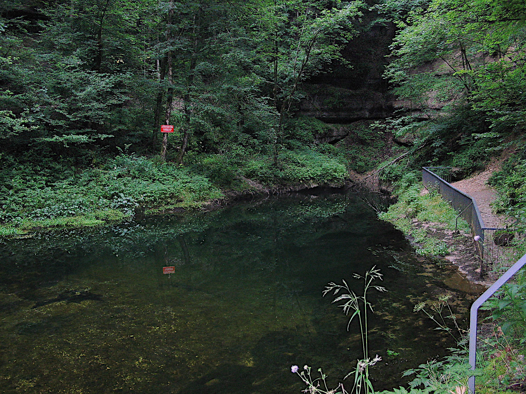
The Source de l’Ain (Ain Spring) is one of the beautiful large karst springs in the Jura. It is the spring or the river Ain, which also has numerous interesting features. The river Ain is a tributary of the Rhône, but it is 190 km long until it finally meets the Rhône, 20 km from Lyon. The spring is located at the far end of a forested valley, a water-filled cave system, which formed along a crack. The water rises though a shaft, which is more lenticular than elliptical, a result of the crack along which it formed. The spring is surrounded by the vertical walls of this shaft, with impressive horizontal layers, on the fourth side a gap allows the outflow of the water. Due to the deep, limestone rich water the spring appears very blue when the sun shines.
Like most karst springs it is seasonal, with heavy flow during snow melt and after heavy rains, and low flow during summer. During draught, it may not only stop flowing, it may fall dry, and the cave below becomes accessible, at least for a certain distance. The ground of the spring becomes a wide gravel road leading steeply down to the much lower level of the water table. There is normally a rope down the slope and into the water, which is not intended for the visitors. It was placed there by cave divers to find their way back when the water is muddy. Please do not damage this rope, if divers are inside, this could cause a deadly accident.
There are numerous trails around the spring and numerous waterfalls and rapids to see. So you can actually walk a trail of any length to see a few of them. The full trail Source de l’Ain is 11.4 km long, with a height changes of 250 m, which will take about 3.5 h walking time. A much shorter loop of about 4.5 km connects the spring with the Cascade du Moulin du Saut and the Cascade du saut des Maillys. Please check a guidebook or hiking website for detailed maps. We will just describe the sites along the short route.
The first is the Cascade du Moulin du Saut, which is created by a hard layer of limestone which forms an escarpment. The water is the river La Serpentine, a right side tributary of the Ain. Further up is a second car park, which can also be used to visit the spring if you are willing to walk the 4.5 km loop.
The trail has a turn-off, a service road leading to the Usine Électrique de Belle Fontaine, a hydroelectric power plant. Here are two bridges, the first across the La Serpentine, the second across the Ain. Right beneath the bridge is the Cascade de la Bellefontaine in the Ain river. Its actually not a waterfall, there are just rapids in the river bed.
Following the road downstream there is a short trail, about 200 m long leading down 50 m in serpentines to the Ain.
Here is the Cascade du saut des Maillys, some waterfalls or better rapids.
It is quite impressive when the Ain has a lot of water, during low water it is calm, and the strange limestone formations with
 potholes,
sometimes wrongly called glacial mills, appear.
There is always a little water in the river, if the main spring falls dry because the water table lowers, there are still some other springs below the main spring which flow.
The trail to the waterfall has railings and viewing platforms.
There are warning signs not to walk in the riverbed, as the power plant above may activate and thus release water into the river which rises quite fast.
Hydroelectric power is very fast, it is used when the grid is in need of more energy quickly, the valve is opened, and a few seconds later the plant produces electricity and water rushes down the valley in a gush.
Nevertheless, this applies only to the riverbed, on the trails you are safe, and most of those signs are actually unnecessary, which makes people ignore them, which is even more dangerous than having no signs at all.
potholes,
sometimes wrongly called glacial mills, appear.
There is always a little water in the river, if the main spring falls dry because the water table lowers, there are still some other springs below the main spring which flow.
The trail to the waterfall has railings and viewing platforms.
There are warning signs not to walk in the riverbed, as the power plant above may activate and thus release water into the river which rises quite fast.
Hydroelectric power is very fast, it is used when the grid is in need of more energy quickly, the valve is opened, and a few seconds later the plant produces electricity and water rushes down the valley in a gush.
Nevertheless, this applies only to the riverbed, on the trails you are safe, and most of those signs are actually unnecessary, which makes people ignore them, which is even more dangerous than having no signs at all.
There is the parking lot at the end of the road which is 200 m from the spring, but it is rather small and might be full on weekends. At the same road is a much larger parking lot about 1.4 km before, and there is also a parking lot at the trailhead to the Cascade du saut des Maillys at the same road. Another parking lot is on the right side of the river named Parking du Moulin du Saut, accessible from the D17 between La Favière and Nozeroy.
 Search DuckDuckGo for "Source de l’Ain"
 Google Earth Placemark
 Ain (rivière)
  - Wikipedia (visited: 03-FEB-2023)
 LA SOURCE DE L’AIN À NOZEROY
  Index
Index Topics
 Hierarchical
 Countries
 Maps
Maps