Σπήλαιο Φράγχθι
Franchthi Cave
Useful Information
| Location: |
Kranidi 213 00.
Between Ερμιονίδα (Ermionida) and Κοιλάδα (Kilada) at the coast. Follow the road from Ligourio to Port Cheli. A few hundred meter after the town Fourni there is a turnoff to the right to Παραλία Φούρνων (Paralia Fournon). Follow this road straight to the west to the beach. Park car and walk to the left, at the end of the beach a trail starts which leads south to the cave. About 1 km/15 minutes walk. (37.4225584, 23.1314563) |
| Open: |
Only after appointment. All year Mon-Fri 8-16. [2025] |
| Fee: |
free. [2025] |
| Classification: |
 Karst Cave Karst Cave
|
| Light: | n/a, bring torch |
| Dimension: | |
| Guided tours: | self guided |
| Photography: | allowed |
| Accessibility: | not wheelchair accessible, trail requires some surefootedness |
| Bibliography: |
Eleni Asouti, Maria Ntinou, Ceren Kabukcu (2018):
The impact of environmental change on Palaeolithic and Mesolithic plant use and the transition to agriculture at Franchthi Cave, Greece.
PLOS ONE. 13. e0207805.
DOI
researchgate
Stiner, Mary & Munro, Natalie. (2011): On the evolution of diet and landscape during the Upper Paleolithic through Mesolithic at Franchthi Cave (Peloponnese, Greece). Journal of human evolution. 60. 618-36. DOI researchgate Kabukcu, Ceren & Hunt, Chris & Hill, Evan & Pomeroy, Emma & Reynolds, Tim & Barker, Graeme & Asouti, Eleni. (2022): Cooking in caves: Palaeolithic carbonised plant food remains from Franchthi and Shanidar Antiquity 2023 Vol. 97 (391): pp. 12–28. DOI researchgate Douka, Katerina & Perlès, Catherine & Valladas, Helene & Vanhaeren, Marian & Hedges, Robert. (2011): Franchthi Cave revisited: The age of the Aurignacian in south-eastern Europe. Antiquity 2011 Vol. 85 (330): pp. 1131–1150. DOI researchgate Lauren E. Talalay (1993): Deities, Dolls, and Devices: Neolithic Figurines from Franchthi Cave, Greece, Excavations at Franchthi Cave, Greece, Fascicle 9, 149 pages, Hardcover, Indiana University Press; ISBN: 0253319811; (December 1993) academia.edu |
| Address: |
Municipality of Ermionidas, M.Merkouri 11, 21300 Kranidi, Tel: 27543-60028.
E-mail: Ephorate of Antiquities of Argolida, Syntagmatos Square, Nafplio 211 00, Tel: +30-27520-27502. E-mail: |
| As far as we know this information was accurate when it was published (see years in brackets), but may have changed since then. Please check rates and details directly with the companies in question if you need more recent info. |
|
History
| 1967 | beginn of excavations by Professor T.W. Jacobsen, Professor of Classical Archaeology and Classical Studies at Indiana University. |
| 1976 | end of excavations. |
| 2011-2013 | developed with EU funds. |
Description
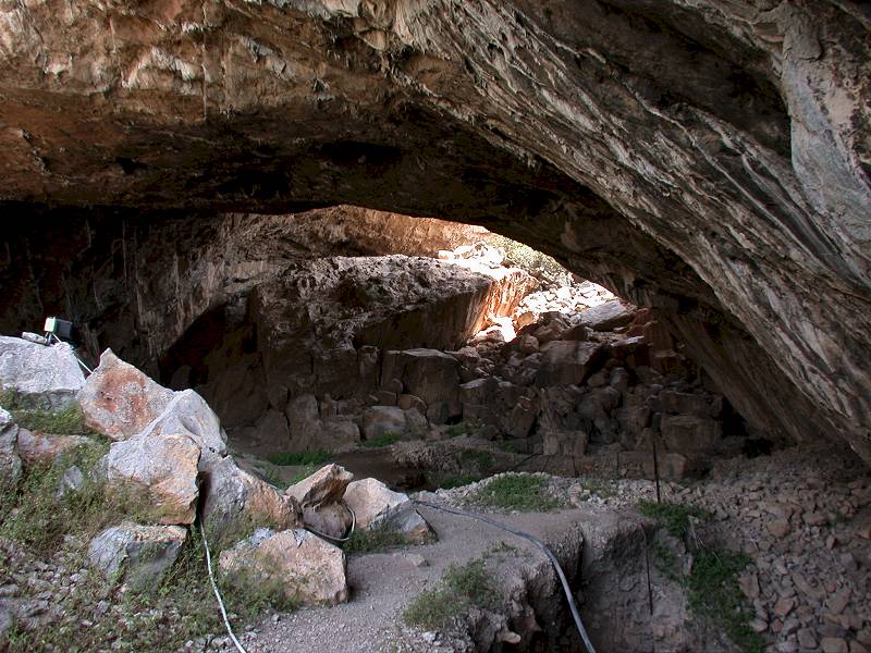
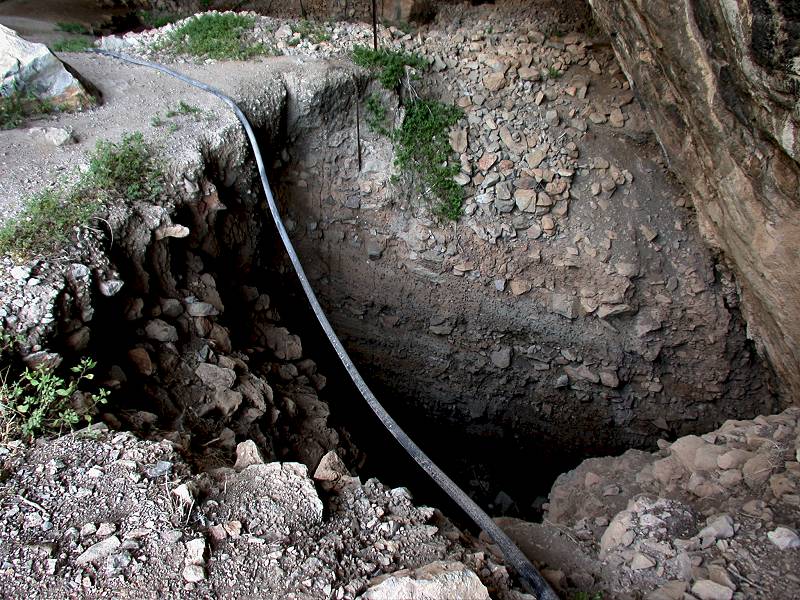
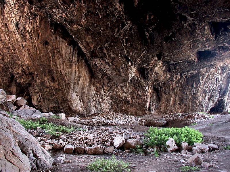
Σπήλαιο Φράγχθι (Spilaio Franchthi, Franchthi Cave) is a very important archaeological cave: it is one of the most important Stone Age sites in Greece. Here is the only good evidence for a continuous sequence of habitation. The earliest evidence is possibly 40,000 BP (Upper Paleolithic). Better evidence begins around 22,000 BP (Middle Paleolithic). The latest finds are from 5000 BP (Late Neolithic). The excavations in the cave left several trenches, the deepest one is 11 meters deep, another one 9 meters deep. After the excavation they were not filled in, so you can still see the work of the archaeologists and the profile of the cave sediment.
The humans occupied the cave only seasonally, they were nomads, hunters and gatherers, and they followed their prey and the seasons. To understand this completely its necessary to realize the climate changes. 40,000 BP was the last cold age, the water was frozen in 3.5 km thick glaciers which covered Scandinavia and Canada and reached Central Europe. Mountain ridges like the Alps were also covered by glaciers. As a result, the sea level was much lower than today. During the last glacial maximum, 25,000 to 20,000 BP it was 120 m lower than today. In other words, the cave was not 10 m above sea level, it was 130 m asl and overlooked a vast coastal plain. Also, the weather was wetter than today, it was more fertile, and there were large herds of animals. There were wild ass and red deer which were hunted.
But the climate became warmer and the sea level rose. The last cold time was the Younger Dryas between 12,900 and 11,700 BP. At that time the cave was not visited, probably the humans went further south where it was warmer. They returned after the end of the cold age, and while they lived here the coastal plain was slowly flooded, about 8,000 BP the sea reached more or less its current level. The people changed their diet, they fed on a variety of small game, wild plants, fish and mollusks. The increasing amount of fish is easy to understand: before it was a long walk to reach the sea. And around 7,000 BC agriculture started, but it is unclear if the inhabitants of Franchthi had begun to practice agriculture or were trading for seeds and meat with others. The use of the cave ended around 3,000 BP, unlike other caves in Greece it was not used as a cave temple during the Bronze Age, which is one of the reasons why the cave sediments are well preserved.
The number of publications on this cave is impressive, it is said to be the most thoroughly studied stone age site in southeastern Europe. And it was discovered more or less accidentially. Professor T. W. Jacobsen, Professor of Classical Archaeology and Classical Studies at Indiana University started the excavation in 1967. He did this only to fill some time, while land use issues at a nearby site were solved. The student Adonis Kyrou had found prehistoric shells at a school trip and informed him about the site. And soon he discovered that this site was much more interesting than expected. Actually it is one of the very few settlements in the world that shows nearly continuous human occupation for such an extended period of time. As a result, the site was excavated for a decade.
The massive involvement of Indiana University led to a series of publications by this institution. We have linked their bookstore below. It’s a good thing that they still offer those books in paperback as well as ebook, although they are about 40 years old now. On the other hand, they charge USD 50 per book, a typical drawback with scientific literature. We have originally listed most of their publications on this page, but with the last review we decided to link more recent papers which are available online for free. If you have the funds for the books follow the link below to Indiana University Press.
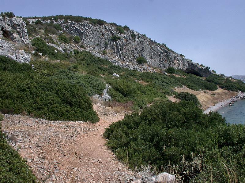
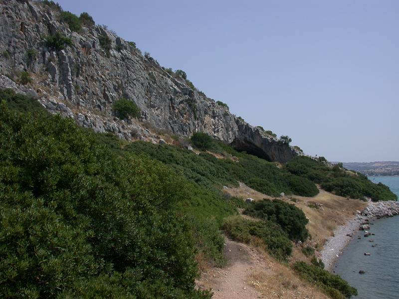
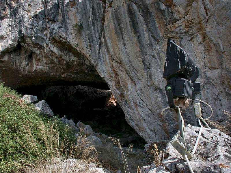
To reach this cave requires a short hike. You can drive by car to the beach near Paralia Fournon, which is mostly frequented by locals and has no infrastructure. But there is the possibility to park the car, and then walk along the shore to the left. The coastline is rocky, with a small cliff, then a steep slope follows which ends at the foot of a second, much higher cliff. The trail follows the slope about 20 m above sea level. Before you reach the cave, there is a landing place for small boats, so it is also possible to reach this place from Koilada on the other side of the bay by boat. However, there is no regular boat connection, so it is much better to walk to the cave. At least the cave is important enough to be illuminated during the evening. There are huge floodlights which are directed to the cliff face with the cave entrance, obviously to be seen from the town on the other side of the bay.
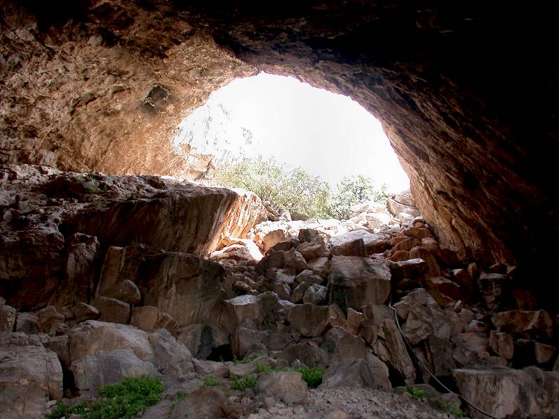
The cave itself is quite impressive. Though only a ruin, it has two huge portals and a short but spacious piece of passage. This is a through-cave, where light from both sides falls into the cave, and there is no dark part of the cave. As a result, it can be visited completely without a lamp, although we nevertheless recommend one if you want to have a look into the archaeological excavation trenches. Until 2011 the cave was completely undeveloped, the trail was just a rough path used by goats and sheep. Then the cave itself was developed with wooden paths and metal railing, which was a very good idea. It protects both the visitors and the site. Unfortunately the cave was also fenced in, and since 2013 it is now necessary to make a reservation. It is still possible to walk to the cave portal, and it is possible to see the whole cave from the fence. Its just not possible to enter. The cave is made accessible by the municipality so possible times are during the operating hours of the municipality.
The name of this cave is mysterious, sometimes it is written Σπηλαιον Φραξθι (Spilaion Fraxthi, Frahthi Cave), sometimes Σπήλαιο Φράγχθι (Spílaio Fránchthi, Franchthi Cave). There are even more transliterations like Σπήλαιο Φράγκθι (Spílaio Fránkthi, Frankhthi Cave) or Phránchthi, but it seems the most commonly used are Frahthi and Franchthi. When we created the page we used the name we found at the site, which was Frahthi, but it seems in the scientific literature uses Franchthi Cave, so we updated the page.
 Search DuckDuckGo for "Franchthi Cave"
 Google Earth Placemark
 OpenStreetMap
 Franchthi Cave (visited: 22-FEB-2026)
 Franchthi Cave (visited: 22-FEB-2026)
 Index
Index Topics
 Hierarchical
 Countries
 Maps
Maps