καταβοθρες
Katavothres - Katabothres
Useful Information

| Location: |
Argostoli, Island Kefalonia, Ionian Islands.
Follow the coast road to the northern tip of the peninsula. From the center of Argostoli signposted. Alternative route: follow road to airport across peninsula, 200 m after sign "Airport 7 km" turn right. Follow road to the northern tip of the peninsula. (38.19380879605804, 20.474330245611128) |
| Open: |
no restrictions. [2021] |
| Fee: |
free. [2021] |
| Classification: |
 Ponor
Doline
Katavothres Ponor
Doline
Katavothres
 Kefalonia-Ithaca UNESCO Global Geopark Kefalonia-Ithaca UNESCO Global Geopark
|
| Light: | n/a |
| Dimension: | |
| Guided tours: | self guided |
| Photography: | allowed |
| Accessibility: | no |
| Bibliography: |
T. R. Shaw (1992):
History of Cave Science,
The Exploration and Study of Limestone Caves to 1900,
2nd edition. Sydney: Sydney Speleological Society, p 89
Ernst W. Bauer (1974): The Mysterious World of Caves, Collins, London. pp 108-112 |
| Address: | Katavothres Club Restaurant, katavothres, Argostoli 281 00, Tel: +30-2671-022221. |
| As far as we know this information was accurate when it was published (see years in brackets), but may have changed since then. Please check rates and details directly with the companies in question if you need more recent info. |
|
History
| 1835 | corn mills built by the Englishman Stevens. |
| 1868 | site visited by Heinrich Schliemann. |
| 1953 | last water wheel destroyed by an earthquake. |
| 1963 | dye tracing experiment by Austrian geologists Maurin, and Zölt revealed the connection to the Kathavothres. |
Description

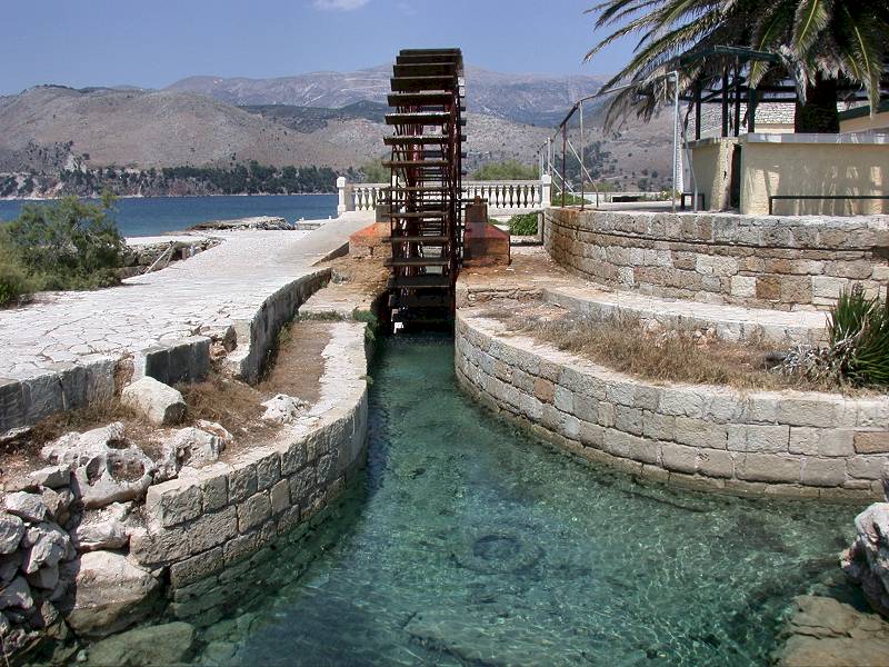
The famous Καταβόθρες (Katavothres, swallow-holes) are an extremely rare geological phenomenon. To be honest, we do not know of any other place on Earth, where this could be found! The seawater flows inland to enter sink holes below sea level. In this area the people used the seawater to run mills.
The site is signposted as καταβοθρες (Katavothres or Katabothres), and we have listed it under this name, although it is actually not a proper name. The site actually has no name, the name Καταβόθρες-Αργοστολίου simply translates Sinks of Argostoli, and there are actually thousands of impressive kathavothres all over Greece. Also, the translation is often bogus, as the translation of Καταβόθρες is river sink, swallow hole or ponor. Thats a hole where water flows in and vanishes. Many pages on the web translate it sinkhole, which is a place where a cave has collapsed and the ceiling sinks into the cave passage, sinkhole is a synonym for doline, and this is definitely not a doline.
It is rather difficult to understand where the water goes, when it disappears below sea level. Obviously, there are some caverns underground, which the water enters. But after some time they are full and the water should stop flowing. Sea level is a physical border, following the law of communicating vessels, water should flow from the side with the high water level to the side with the low level until both were at the same height. So after some time, all caverns should be filled at the same height as sea level. In the Mediterranean Sea, there is only very little tide, so this force is no good explanation.
Over the time numerous theories were made up, how this could work. They all contributed some details to the modern theory. Our explanation is a bit more detailed, but this natural phenomena is rather difficult to explain. You will find it in the links below.
Mousson guessed the source of the movement in volcanic activity in the ground, heating up the water. Warm water has bigger volume and a lower specific weight than cold water, so it would move up to the surface again. This would explain where the water goes. However, there are two problems with this theory: there are no thermal springs around, and how should this lower the water level at Argostoli?
Fouqué used the law of communicating vessels for his theory. If the physical attribute of the water changes from one side to the other, the water level would be different in both tubes. The tube with the heavier liquid would have a lower level. Possible ways to change the specific weight are heat, like Mousson guessed, but also addition of sweet water.
Wiebel discovered the Ainos springs near Drapano, with their brackish water. He guessed that salt water from Argostoli was conducted through underground channels in a depth of 20 m and mixed with sweet water before it
The engineer Marketos discovered in 1940 a characteristic of fast-flowing water: water flowing through a tube will produce lower pressure. This principle is used to build pumps, which work when they are connected to a tap. But the theory that the water was pumped from Argostoli to Karavomilos is not very likely, as the necessary geometric shape of the cavern would have long been destroyed by one of the frequent earthquakes. But this principle explains the relatively low water level at Melissani Cave, as the low pressure in the water lowers the water level.
An important hint for the modern explanation was the connection to springs at Karavomilos, northwest of Sami, on the other side of the island. This was proven by dyeing experiments, made by Ioannis Petrocheilos and the Austrian hydrogeologists Maurin and Zölt. On the 26-FEB-1963 they made a dyeing experiment by dropping 140 kg of uranine, a very intensive green colour, into the Katavothres. The colour arrived at Melissani Cave and the springs at Karavomilos fourteen days later, on 12-MAR-1963.
In 1989 the French scientist Drogue explained the situation with the existence of a cave system, the different level of the entrances on both sides of the island and the different specific weight of salt and brackish water.
Diary of Heinrich Schliemann (1868).
Den 7. Juli am Abend fuhr ich mit dem Dampfboot der hellenischen Gesellschaft nach Argostoli, auf der Insel Kephallonia, wo ich am folgenden Tage 5 1/2 Uhr Morgens ankam. Am Eingang des Hafens beobachtet man ein sehr merkwürdiges Phänomen, welches ganz gegen die Ordnung der Natur zu sein scheint: denn, während sich sonst die Flüsse vom Lande ins Meer ergiessen, ergiesst sich hier das Meer an zwei Stellen in das niedrige, ausgehöhlte Ufer in starken Strömungen, welche sich in unterirdische Gänge verlieren. Das Wasser fliesst beständig, und mit solcher Regelmäßigkeit und Gewalt, dass man über den Flüssen zwei grosse Kornmühlen erbaut hat, welche Tag und Nacht arbeiten, und deren Ertrag bedeutend ist.
On the evening of 7 July I took the steamboat of the Hellenic Company to Argostoli, on the island of Kephallonia, where I arrived the following day at 5 1/2 o’clock in the morning. At the entrance to the harbour one observes a very strange phenomenon, which seems to be quite contrary to the order of nature: while the rivers usually pour from the land into the sea, here the sea pours at two points into the low, hollowed shore in strong currents, which are lost in underground passages. The water flows constantly and with such regularity and force that two large grain mills have been built above the rivers, which work day and night and produce a considerable yield.
The Katavothres of Argostoli are Geosite No 14 of the
Kefalonia-Ithaca UNESCO Global Geopark.
- See also
 How does it work?, the scientific explanation of the strange situation.
 Search DuckDuckGo for "Katavothres"
 Google Earth Placemark
 Katavothres (visited: 01-NOV-2024)
- Kefalonia Katavothres (visited: 01-NOV-2024)
- Katavothres - Kefalonia (Greece) (visited: 01-NOV-2024)
- KATAVOTHRES (visited: 01-NOV-2024)
 Index
Index Topics
 Hierarchical
 Countries
 Maps
Maps