Λιμνι Τακα
Limni Taka - Lake Taka
Useful Information
| Location: |
Near Vouno, between Pallantio and Evandros.
(37.432545, 22.371462) |
| Open: |
no restrictions. [2023] |
| Fee: |
free. [2023] |
| Classification: |
 Karst lake,
Ponor. Karst lake,
Ponor.
|
| Light: | n/a |
| Dimension: | A=657 m asl. |
| Guided tours: | self guided |
| Photography: | allowed |
| Accessibility: | yes |
| Bibliography: | |
| Address: | |
| As far as we know this information was accurate when it was published (see years in brackets), but may have changed since then. Please check rates and details directly with the companies in question if you need more recent info. |
|
History
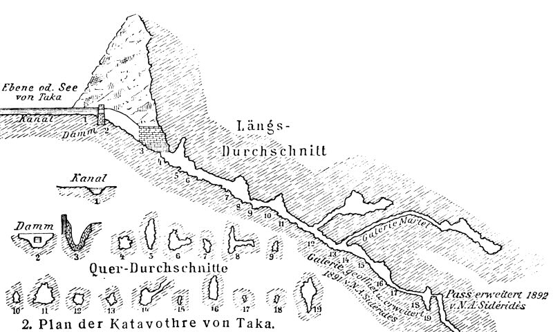
| 18-SEP-1891 | E A Martel and N. Sideris (engineer) explore the sink holes (ponors) of lake Taka. |
| 2000 | dam built with the support of an EU-fund. |
Description
Λιμνι Τακα (Lake Taka) is located on the Peloponnese, in the southern area called Arkadia, between Pallantio and Evandros. This intermittent karst lake is formed by springs during winter, the rainy season. It is drained only by καταβόθρες (Katavothres, Swallow Holes), which is the Greek name for ponor. The seven ponors are located at the foot of the surrounding hills or in dolines, there is no above ground outflow. The water flows through caves towards the southeast and reappears in submarine springs in the Mediterranean Sea.
In most years the lake dries out completely, in wet years a little rest remains. The lake forms temporary marches and is an important home to many birds like moorhens, white egrets, glossy ibises, wild ducks, snake eagles, terns, swans, and kingfishers. It is an important resting place for migratory birds. Also, various mammals and amphibians live here. Flora includes willows and lilies. The wetland site is protected as a Natura 2000 habitat.
When the lake has dried the flat ground is humid and very fertile, very good for agriculture. This ideal situation was known and used for a very long time, at the shores of the lake lie the remains of ancient Pallantion. This is one of the oldest and most famous ancient cities in Arcadia. The area was called Manthourian Field in the 19th century, as the historians believed that the ancient city of Μανθυρέα (Manthyrea), which was mentioned by Pausanias, once was here. He only mentioned that an image of the goddess Athena he describes was created in Manthyrea, but the location of this city is still unknown. But probably Pallantion was once called Manthyrea.
As today the water is important for irrigation a rectangular dam was built in the center of the lake. The ground of the lake is water tight, there is no ponor in this area and smaller cracks are sealed by a layer of clay sediments. So the water stays in the dammed area over summer. The dam was built around 2000 with the support of an EU-fund. In wet years drainage is too slow and farming cannot start in due time. That’s why the farmers keep the kathavothres free from obstructions, if they are clogged its impossible to use the lake for farming.
Although today almost completely forgotten, except for some bird enthusiasts, this place was once a center of scientific exploration. The Katavothres of Taka were explored by E. A. Martel and N. Sideris, a Greek engineer. They discovered a deep cave system, an underground river gorge. Martell published their discoveries and the survey in one of his books, and soon the cave became world-famous. It was even reprinted in the German encyclopedia Mayers Konversations-Lexikon around 1900. Nevertheless, those caves are not developed and rather dangerous, only accessible to speleologists.
 Search DuckDuckGo for "Lake Taka"
 Google Earth Placemark
 Lake Taka - Wikipedia (visited: 16-MAR-2023)
 Lake Taka (visited: 16-MAR-2023)
 Index
Index Topics
 Hierarchical
 Countries
 Maps
Maps