Σπηλαιο Αγγιτη
Spilaio Aggitis - Cave of Aggitis - Springs of the River Aggitis
Σπηλαιο Μααρας
Spilaio Maará - The Subterranean River Maará
Useful Information
| Location: |
Πηγές, Aggitis 662 00.
20 km northwest of Dráma. From the main road Thessaloniki-Kavala, turn north at Nea Kerdilia, national road 54 km to Dráma. In Dráma turn left towards Kato Nevrokopi. After 18 km turn left to Kokinógia (3 km), at Kokinógia turn right to Aggitis. At the road right before the village Aggitis. Well signposted. (41.2211246, 23.8915070) |
| Open: |
Summer daily 10:30-19. Winter daily 10:30-17. [2024] |
| Fee: |
Adults EUR 7, Children EUR 6, Disabled, Students, Seniors (65+) EUR 6. Groups (25+): Adults EUR 4.50, School Children EUR 4. [2022] |
| Classification: |
 Karst Cave
River Cave Karst Cave
River Cave
|
| Light: |
 Electric Light
Coloured Light Electric Light
Coloured Light
|
| Dimension: | L=14,000 m, T=11.5 °C (water), T=12.5 °C (air), H=90-95%, A=129 m asl. |
| Guided tours: | L=500 m. |
| Photography: | allowed |
| Accessibility: | no |
| Bibliography: |
Esprit-Marie Cousinéry (1831):
Voyage dans la Macédoine I-II,
p. 47, Imprimerie Royale, Paris 1831.
Dr. Katerina Trantalidou (2000): The History of a Cave at the Angitis Springs, E. T. Koutrakis, Y. Machino, A. Kallianiotis, D. M. Holdich (2005): Austropotamobius torrentium (Schrank, 1803) in the Aggitis Cave (northern Greece). Is it a cave-dwelling species?, Bull. Fr. Pêche Piscic. (2005) 376-377 : 529-538. pdf Ch. Pennos, S.-E. Lauritzen, S. Pechlivanidou, Y. Sotiriadis (2016): Geomorphic Constrains on the Evolution of the Aggitis River Basin Northern Greece (A Preliminary Report), Bulletin of the Geological Society of Greece, vol. L, p. 365-373. Proceedings of the 14th International Conference, Thessaloniki, May 2016. online pdf DOI Jean-Paul Novel, Agoro Dimadi, Anna Zervopoulou, Michel Bakalowicz (2006): The Aggitis karst system, Eastern Macedonia, Greece: Hydrologic functioning and development of the karst structure, Journal of Hydrology (2007) 334, 477–492. DOI |
| Address: |
Cave of Aggitis, Aggitis 662 00, Tel: +30-25220-60460, Fax: +30-25220-60460,
E-mail: Office ΔΗ.Κ.Ε.Π. Tel: +30-25220-23620. City of Prossotani, community of Kokkinogeia, Tel: +30-522-60092 or +30-522-60075. DETASPA (Communal Organisation for the Development of the Springs of the River Aggitis), Tel: +30-521-30843 or +30-521-31938. |
| As far as we know this information was accurate when it was published (see
years in brackets), but may have changed since then. Please check rates and details directly with the companies in question if you need more recent info. |
|
History
| 17?? | visited by Esprit-Marie Cousinéry. |
| 190? | water wheel built. |
| 1930 | water wheel restored. |
| 1960 | water wheel abandoned. |
| 1952 | exploration of the first 70 m to the first siphon by Anna Petrocheilou and Ioannis Petrocheilos. |
| 1978 | first dive through the siphon by French and Greek speleologists, lead by Avagianós. |
| 1980 | entrance tunnel built. |
| 1992 | archaeological excavations in the cave and the surrounding area. |
| 1999 | cave developed as a show cave. |
| 2000 | opened to the public. |
Description

The river Aggitis has its spring at the small village Aggitis, northwest of Dráma, at the foot of a marble mountain, belonging to the Rodopen mountain range. The marble of the Rodopes is quarried in numerous small quarries in the area. The river runs south from its springs, through a wide valley and enters a gorge near Alistrati. Then it runs again through a wide valley where it meets the river Strimonas, which flows into the Mediterranean Sea at Amfipoli.
The springs of the river Aggitis are called Maara Springs. They are the resurgence of a huge cave river, which sinks on the Káto Nevrokópi plateau into the sinkholes of Ochyro. Then it flows underground to the south for about 11 km, as the crow flies. The underground riverbed has mostly huge passages, some wide chambers, and some sumps. This cave is either called Σπηλαιο Αγγιτη (Cave of Aggitis) after the river, or Σπηλαιο Μααρας (Cave of Maara) after the springs. Sometimes it is called Σπήλαιο Πηγών Αγγίτη (Spílaio Pigón Angíti, Aggitis Springs Cave).
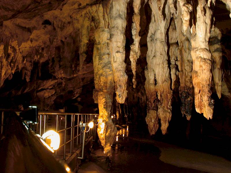
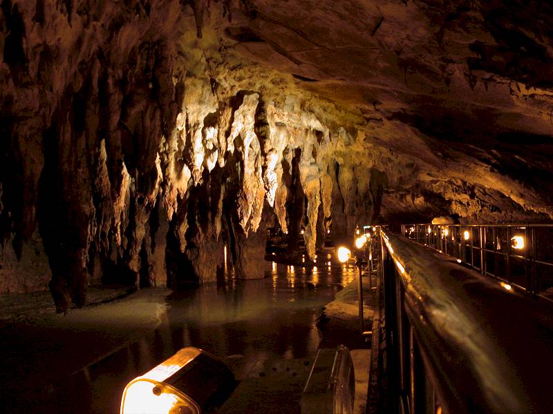
The first part of the river cave, with a length of some 500 m, is developed by a path built on stakes, it ends at the first sink. This is the show cave part of the cave. The next 2.5 km of cave passage requires some easy dives through sinks, but may be visited by physically fit visitors. Guided tours including rent equipment are offered after appointment. The rest of the cave is accessible only to specialized cave divers. At the moment about 8 km are explored, some 4 km to the Ochyro sinkholes are still unknown.
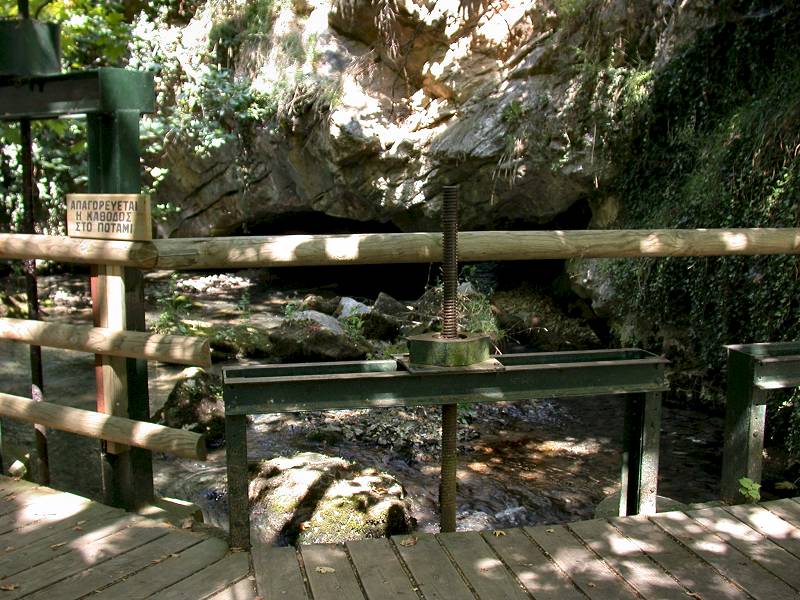
There was an early human habitation at the cave dating back to 3000 B.C. Remains were found inside the cave, close to the entrance. Later during Roman times, the cave was mentioned by Herodotus. In the early Middle Ages, during the 6th century A.D., fortifications were built at the cave entrance. The first recorded visit of the cave was made by the French consul at Thessaloníki, Esprit-Marie Cousinéry, who travelled around Macedonia for 40 years. After his retirement, he wrote a book named Voyage in Macedonia about the area, in which he also describes his cave visit (see bibliography above). His visit happened at the end of the 18th century, and he visited only the first hall. He named this hall Nymphaion, as he thought this was a place of worship for water gods. The sources of the river were used by the locals for water supply and as a source of power. They built water mills right at and below the spring. Soon they discovered the first big hall, which has a big opening to the surface, a doline where the roof caved in. It is also accessible from the cave entrance, but the ceiling is very low.
The huge first hall was used in the 19th century to install a water wheel, which pumped water up into a water pipe. At this time, the first short tunnel was built to access the first hall. The cave was the drinking water supply for the town and irrigation water for the nearby tobacco fields. There was a 6 km long channel, which was also built at this time.
Then in 1952 the new Hellenic Speleological Society made the first exploration, but a siphon stopped any research after only 70 m. In 1978, with much better equipment, a group of French and Greek speleologists made a new attempt to explore the cave behind the siphon. They discovered a passage of 500 m which again ended at a siphon. This part of the cave is today’s show cave. Soon a second short tunnel was built to allow people to pass the first siphon. Anna Petrocheilou, who was president of the Hellenistic Speleological Society at this time, suggested the cave to be developed as a show cave. But it seems the cave fell into a sort of sleep, as it took until the year 2000, when the cave was finally opened to the public.
Today a new entrance tunnel allows comfortable access to the main passage and enters the cave at the so-called Beach Chamber. The path, built on a bridge above the river, shows the section to the next siphon, and the visitors have to walk back the same path to the Beach Chamber. Here a bridge crosses the river, and a short tunnel leads to a narrow section of the cave, and another tunnel leads to the entrance hall. The water wheel, the huge doline and a small chapel are the highlights at the end of the tour.
The river passage is very interesting, huge stalagmites hanging from the ceiling, sometimes almost to the surface of the water. The path is quite new, built on stainless steel with concrete plates to walk on. The cave is lit with yellow lamps lighting the path and white lights for the formations, which are turned on and off by motion detectors. The cave has no steps, despite the exit from the water wheel, so it is suitable for disabled visitors.
At the new tunnel, today’s entrance tunnel, an archaeological excavation is located. This excavation revealed numerous Stone Age remains. But this was not the place were the hunters lived, the human remains were transported by the water of the river and the accumulated in a small depression.
 Search DuckDuckGo for "Maara Aggitis Cave"
 Google Earth Placemark
 OpenStreetMap
 Aggitis River Cave, official webpage (visited: 03-NOV-2024)
 Index
Index Topics
 Hierarchical
 Countries
 Maps
Maps