Jankovich-barlang
Useful Information

| Location: |
Öreg-kői, Bajót.
(47.7236676, 18.5753373) |
| Open: |
No restrictions. [2022] |
| Fee: |
free. [2022] |
| Classification: |
 Karst Cave Karst Cave
|
| Light: | bring torch |
| Dimension: | L=88 m, VR=24 m, A=330 m asl. Cadastral Number 4661-1. |
| Guided tours: | self guided |
| Photography: | allowed |
| Accessibility: | no |
| Bibliography: |
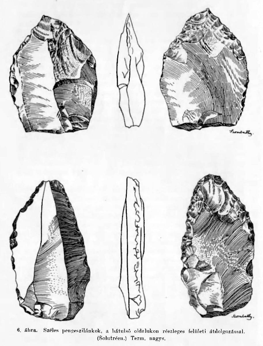
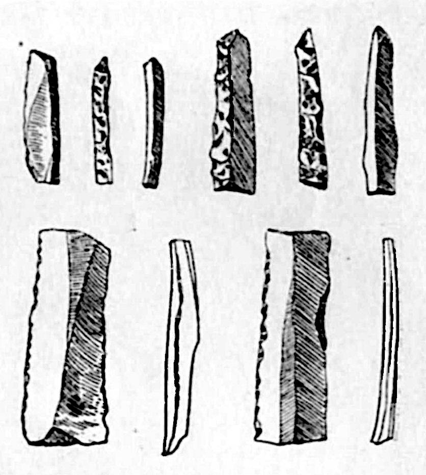
Kálmán Szombathy (1915):
Jankovich-barlang, széles pengeszilánkok,
Barlangkutatás, 1915. 3-4. füz. 138. old.
|
| Address: |
Gerecse NatúrPark Látogatóközpont, Cím: Bajót, Péliföldszentkereszt, Tel: +36-620-263-7653.
Hungarian National Museum, 1088 Budapest, Múzeum krt. 14–16., Tel: +36-338-2122, Tel: +36-317-7806, Tel: +36-327-7773. E-mail: |
| As far as we know this information was accurate when it was published (see years in brackets), but may have changed since then. Please check rates and details directly with the companies in question if you need more recent info. |
|
History
| 1913-1918 | excavations by Jenő Hillebrand, supported by Béla Jankovich, Minister of Culture. |
| 1924-1926 | second excavation by Jenő Hillebrand. |
| 1982 | declared an archaeologically significant cave and a highly protected cave. |
Description


Jankovich-barlang (Jankovich Cave) is actually a cave ruin, somewhere between collapsed cave and natural bridge. Located on a hill it was a shelter for prehistoric hunters and is one of the archaeologically most important sites of Transdanubia. While it is one of the six highly protected caves in the Gerecse Mountains, it is also located in a popular hiking area and a hiking trail leads to its entrance. The Öreg-kő (Old Stone) is a 375 m high mountain of Dachstein limestone (ki) with numerous caves. It has impressive cliff faces and is more than 100 m higher than the surrounding plain. There are also Öreg-kői 1. sz. zsomboly (Old Stone No. 1 tomb), Baits-barlang (Baits Cave), Szalay-barlang (Szalay Cave) and Öreg-kői 2. sz. zsomboly (Old Stone No. 2 tomb). Those caves are all closed by gates. All are of great archaeological interest, but only the rather unimpressive entrances are accessible.
The cave is located at a short trail which branches off the Országos Kéktúra (OKT, National Blue Trail) which is the Hungarian part of the European Long Distance Walking Route E4. The closest car park is at Gerecse Natúrpark Látogatóközpont Tourist Information Center, which is on the trail. It is also a good starting point as it offers brochures and info on the site, and sells maps. From here follow the white rectangle with the horizontal blue line northwest along the Lourdes-i barlang (Lourdes Grotto) to the Öreg-kői. At the resting place under the rock the trail marked with a blue Omega (Ω) for cave, leads 200 steps uphill to the Baits-barlang (Baits Cave) and immediately afterwards the Jankovich-barlang is reached. There is also a trail with wooden stairs which leads steeply to the top of the Old Stone. The view is great, you can see the surrounding hills and the meandering Danube with the Basilica of Esztergom.
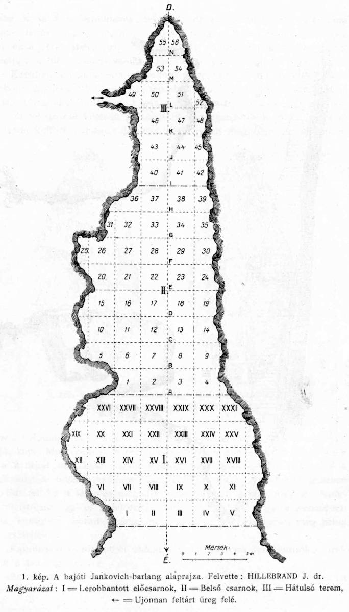
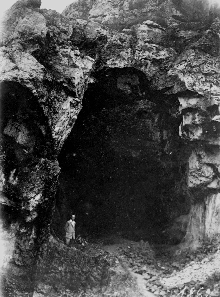
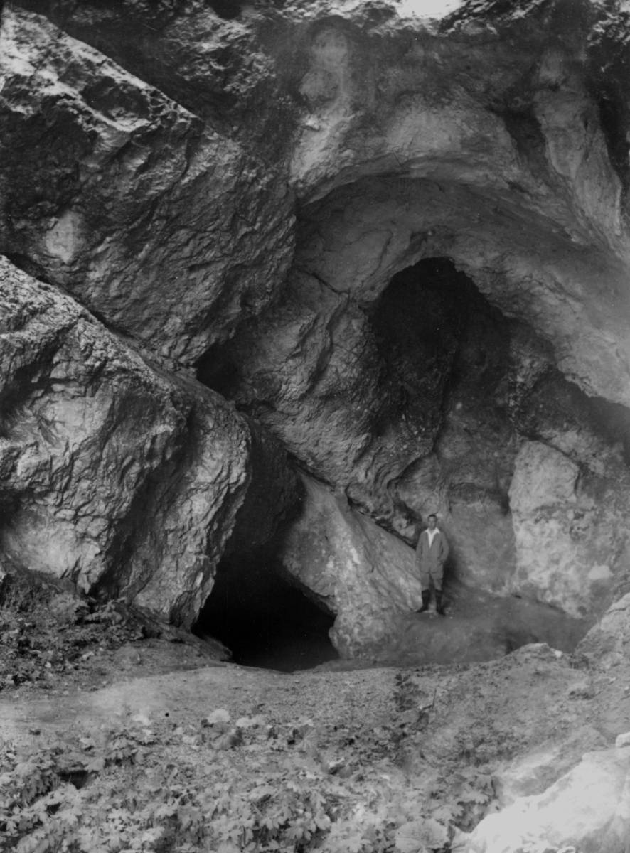
Jankovich Cave is located close to the hilltop, only about 20 m below, but it is looking north, which is quite exceptional for shelters. Normally our ancestors preferred caves facing south, because the sun shining into the shelter made it warm and comfy. The cave has a single huge chamber, with a huge entrance portal, 9.5 m wide and 8 m high, a circular hole of 7.5 m diameter in the ceiling, and is 25 m long. There is a second part below, a 12 m long passage which is between 1 m and 2 m high and is connected to the upper level by a shaft, which is completely filled with huge blocks. The cave was heavily altered by human action. Before it was protected, at the beginning of the 20th century the entrance section was quarried. The first part of the cave was destroyed, the cave was originally about 35 m long, and what we see today is actually the quarry wall. We can only imagine how many remains of our ancestors were completely destroyed before the cave was first excavated. And of course several meter thick sediments inside the cave were removed during the excavations lowering the floor substantially.
Jankovich Cave was long known, but archaeological excavations started in 1913 with Jenő Hillebrand (*1884–1950). He excavated two times, 1913-1918 and 1924-1926, and described his results in a rather erratic and incomplete way. The campaigns were not very systematic, and he published contradictory excavation reports on the features, stratigraphy and location of the recovered artefacts. Most likely because he actually just had some men dig out the sediments and sieve them through. This is not his fault, such techniques were quite common until the 1930s. He only distinguished the main layers which were easy to separate due to different colours. Jenő Hillebrand and Tivadar Kormos surveyed the cave, the maps on this page are from them. However, his research results of the site were later sorted by the famous László Vértes (*1914-✝1968).
In a way the excavation of this cave was both, too late and too early. It was too late for the already destroyed part of the cave, but too early because the excavation destroyed the remaining content of the cave almost completely. At the beginning of the 20th century archaeology developed many quite important techniques for excavations, the most important probably the meticulous stratigraphy. The findings are today exactly surveyed, so it is possible to determine different layers and afterwards it is known which item is from which layer. That’s quite essential for dating and for determining different cultures and chronological development. Jenő Hillebrand did not break down the layers into levels so his finds cannot be divided. At he removed the sediment completely, in 1956 at the next excavation by László Vértes, no undisturbed layers could be found anywhere in the cave. In other words: we have all the tools and bones and artifacts, but have no idea which were made by the same people and which by other people thousands of years later. And it is impossible to date stone artifacts by physical methods. The dating was done by applying cultural theories, of which we do not know if they are correct or not, and by applying them instead of crosschecking them, we will never find the errors in the theory.
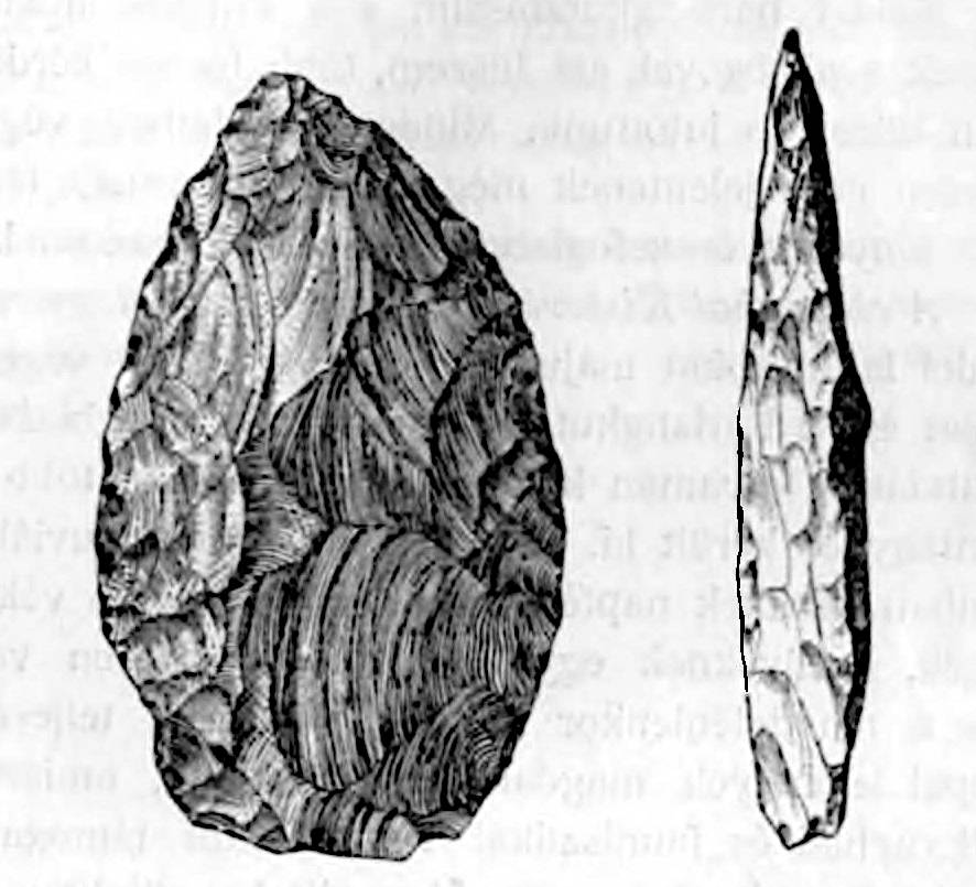
Nevertheless the findings are exceptional and rather unique, the cave is the type locale of the Jankovich culture.
The finds were partly transferred to the Magyar Nemzeti Múzeum (MNM, Hungarian National Museum) and partly to the Institute of Geology. Also, three objects were sent to New York in 1925 and nine objects to the collection of the Benedictine grammar school in Esztergom.
The cave was originally named Öregkő-barlang (Old Stone Cave), sometimes Bajót-barlang after the nearby village, but these names are not very helpful as there are numerous caves in the hill. Nevertheless, those various names are used in literature until today, which has a great potential for misunderstanding and makes it quite difficiult to identify which of the numerous caves on the hill is actually meant. The work of Jenő Hillebrand received financial and moral support from Béla Jankovich, the Minister of Culture. To honor him Jenő Hillebrand renamed the cave Jankovich Cave and placed an inscription on the wall.

 Search DuckDuckGo for "Jankovich-barlang"
 Google Earth Placemark
 Jankovich-barlang
  - Wikipedia (visited: 15-APR-2022)
 Látnivalók (Gerecse NatúrPark Látogatóközpont) (visited: 16-APR-2022)
 Index
Index Topics
 Hierarchical
 Countries
 Maps
Maps