Qasam Barrani Cave Houses
Useful Information
| Location: |
Near Mellieħa.
Highway 1 Mellieħa Bypass, below the two hairpin bends. On the uphill side turnoff of single lane gravel road. (35.958201, 14.352117) |
| Open: |
no restrictions. [2024] |
| Fee: |
free. [2024] |
| Classification: |
 Karst Cave Karst Cave
 Cave House Cave House
|
| Light: | bring torch |
| Dimension: | |
| Guided tours: | self guided |
| Photography: | allowed |
| Accessibility: | no |
| Bibliography: |
Keith Buhagiar (1997):
The San Niklaw Cave Settlement at Mellieħa, Malta
Melita Historica (new series), 12 (1997) 2(131-137), 1997;
researchgate
pdf
|
| Address: | |
| As far as we know this information was accurate when it was published (see years in brackets), but may have changed since then. Please check rates and details directly with the companies in question if you need more recent info. |
|
History
| 1852 | earliest references to the ‘Ghar u Casa’ at the National Archives. |
| 1862 | cave excavated by T. A. B. Spratt. |
| 1999 | caves declared Class B site of archeological importance under an emergency conservation order. |
Description
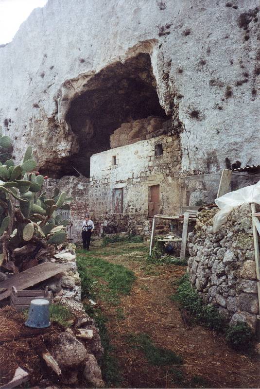
© Tony Oldham, 23-FEB-2002, with kind permission.
© Tony Oldham, 23-FEB-2002, with kind permission.
The name Qasam Barrani Cave Houses actually does not exist, we do not know how those cave houses are named or if they even have a name. So we named it Qasam Barrani Cave Houses after the Qasam Barrani area where it is located. On the picture you can see that the gras is cut and the site, while not inhabited, is used for agriculture. But this was more than 20 years ago. Today the site is abandoned, overgrown, and though a visit is actually not officially allowed, it’s not gated. This is a quite spacious cave chamber with a huge portal and a farmhouse inside. It’s still possible to identify the barns and stables. The small but spectacular cave settlement is located right below the two S bends of Highway 1. As Malta has left-hand traffic and the road is four-lane with structural separation, you have to turn left into the dirt road coming from the north. For a first-hand description see the following text by Tony Oldham.
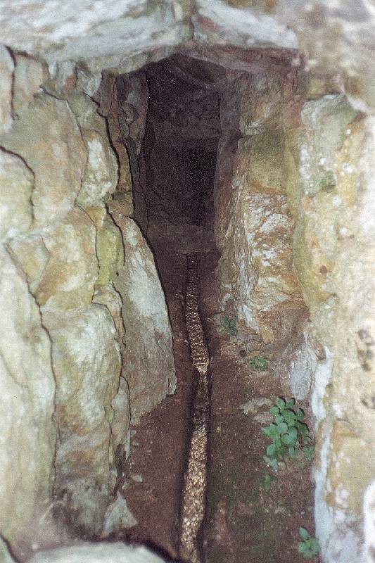
To the south of the village of Mellieħa are a series of limestone outcrops honeycombed with caves. Most of the caves have been adapted in some ways, originally for habitation, but today their use is mainly agricultural. At the side of the No 1 Gozo to Valetta trunk road, about 2 km south of the village is a double ’S’ bend in the road. Park in the layby and seek permission from the nearest allotment holder. A path leads to one of the largest cave entrances over 20 m high but blocked by a two-storey building, a miniature Predjama! There are more caves with entrances partially blocked with dry stone walls on the opposite side of the valley. In the valley floor, there is a spring with a long line of stone runnels leading water into a tank. A scene unchanged since Roman times.
Text by Tony Oldham (2002). With kind permission.
The town Mellieħa is located on Mellieħa ridge, and Highway 1, which connects the northernmost and southernmost point of the island, runs along the southern side of the town. The northern side of Mellieħa ridge is very steep and has several short and deep valleys, the city was built on the ridge and the hills between the valleys. The steep valley slopes are riddled with natural caves, which offered some opportunity to early settlers. It was easier to build inside a cave, as some walls and the ceiling already existed, the location on a steep slope had strategic opportunities, some caves had wells, and it was not necessary to destroy fertile land for the construction of houses. Also, the temperature inside the cave was more or less acceptable all year, without heating or air conditioning. Its understandable why people built cave houses or churches in most caves, the even extended them or dug additional caves.
Mellieha has numerous cave houses, and they are actually not developed for tourism., not a single one. And that’s despite the fact, that all those cave houses were declared Class B sites of archeological importance in 1999. No measures have yet been taken to preserve them. However, in the era of Urban Exploration there are numerous webpages about visits to such overgrown abandoned cave houses. On the opposite side of the valley is the quite famous San Niklaw Cave Settlement located, which has a cave church and several houses. It also has a spring which flows all year and is quite important for agriculture until today. Again, the site is not developed and most likely private property, but there are no access restrictions. And numerous cave houses can be found along Triq Il-Marfa which goes down from the city to the coastal plain at the bay. Most houses are on the eastern slope of the valley, below the famous Sister Island Outlook. Access is from the end of Triq Dun Franġisk Sciberras.
All those cave houses are abandoned, and the reason is a development in the 20th century, especially after World War II. The cave houses, while they were still inhabited, were known as Ghar u Casa (Cave and House). This was the name of this group of cave houses as well as the name for this type of cave house. But after the War people built better houses with water, sewage, and electricity, which those cave houses lacked. People moved away and at some point the cave houses were inhabited only by the poor and the old. The name was spoken as Gharukaza in Maltese and soon the term became the meaning disgrace, with a negative connotation. People found living in caves shameful. There were similar developments all around the Mediterranean Sea in such cave cities, see Matera in Italy for another example. As far as we know there was no governmental relocation of the inhabitants in Melliha though, the people moved away one by one, the last inhabited houses were abandoned in the 1980s or 1990s.
We have listed this cave house as a representative of all the other mentioned and not mentioned cave houses in the area. Two of the caves here are actually listed separately, one is a cave bar inside a hotel, the other is a cave church. And a third one, which was discovered during construction works was destroyed by the same construction works. The cave was never named, but it got some fame after the cave sediments were post-mortem examined by T. A. B. Spratt. It’s not possible to determine its actual location, but it was located on the same northern slope of Mellieħa ridge.
In the Upper Coralline Limestone near the village of Mellieħa and about 60 m [some accounts give 200 m north] north of the chapel. Overlooking and about 90 m above the sea, the cave contained stalactites, stalagmite floors and water-worn pebbles. The cave was originally discovered and destroyed in the 1840’s when constructing a road to the Cemetery. Its contents were used as rubble to fill up the interstices in the wall and undoubtedly also for road construction. Excavated by T. A. B. Spratt in 1862 who found Pleistocene bone deposits containing Hippopotamus.
Text by Tony Oldham (2002). With kind permission.
 Search DuckDuckGo for "Qasam Barrani Cave Houses"
 Google Earth Placemark
 OpenStreetMap
 Ghar u Casa, Mellieha (visited: 13-FEB-2025)
 Index
Index Topics
 Hierarchical
 Countries
 Maps
Maps