Il-Maqluba
Useful Information
| Location: |
Qrendi, Malta.
Qrendi village. Stairs leading down from the chapel of Saint Matthew. (35.8308520, 14.4574265) |
| Open: |
No restrictions, daylight advisable. [2018] |
| Fee: |
free. [2018] |
| Classification: |
 Collapse Doline Collapse Doline
|
| Light: | n/a |
| Dimension: | D=15 m, L=100 m, W=66 m. |
| Guided tours: | self guided |
| Photography: | allowed |
| Accessibility: | no |
| Bibliography: | |
| Address: |
Kunsill Lokali Qrendi, 7, Triq il-Knisja, Il-Qrendi QRD 1103, Malta, Tel: +356-2168-0404, Tel: +356-2164-0524.
E-mail: |
| As far as we know this information was accurate when it was published (see years in brackets), but may have changed since then. Please check rates and details directly with the companies in question if you need more recent info. |
|
History
| 23-NOV-1343 | formed during a storm or probably an earthquake. |
Description
Il-Maqluba is a huge collapse doline or sinkhole. The name means "reversed", "upturned", or "upside-down" in Maltese. Its formation happened in historic times and is thus documented: on 23-NOV-1343 it was formed during a violent winter storm, probably there also was an earthquake. The most obvious guess is that the collapse was either caused by an earthquake or even more likely was the source of a local earthquake. But legend is much more fantastic. It tells about a collapsed underground cavern excavated by the Phoenicians. Or it was formed by the wrath of God or Devil (choose one) which makes it either an evil or sacred place. Whatever the reason was: in the 14th century a chapel was built at the edge of the sinkhole which is consecrated to Saint Matthew. The first written mention of this chapel was by Inquisitor Dusina in the report of his pastoral visit to the Maltese Diocese between 1574 and 1575.
A different version of this legend goes like this:
There are numerous variations to this legend. Sometimes the warner was a man, sometimes it was a nun. Also, the event was accompanied by a storm, a tempest, an earthquake or whatever. Or the chapel already existed and the collapse stopped right in front of it. Or the place of the chapel was the place where the good woman lived and was spared, and later the chapel was built at this place. The hamlet is called tal-Maqluba or Hal-Lew.
And then there is the story of Phoenician wells or probably cisterns.
But it is not only the legends about the sinkhole’s origins which are varied. The facts about its size are similarly variable. Some say the sinkhole was covering an area of some 6000 m², other say 4,765 m². It’s unclear which one is true, the guess that the first number is rounded and thus less reliable may be misleading. The diameter is given around 50 m and the depth around 15 m. The satellite image of Google gives a size of 100 m from north to south and a width of 66 m east-west. This is about 5,000 m².
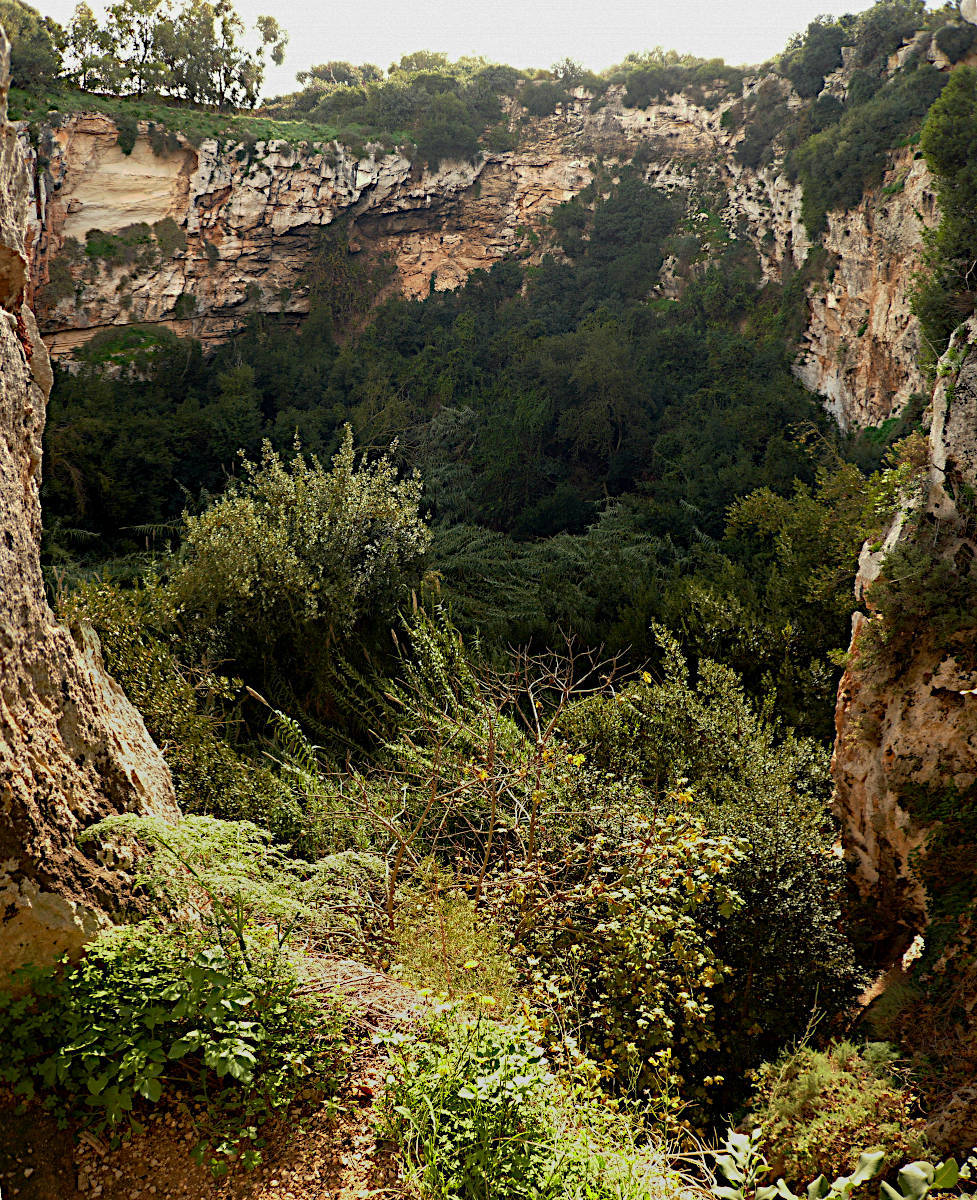
Lest stick with the obvious first. This doline is a typical sinkhole, a cave below collapsed, creating an elliptical hole with vertical or overhanging walls. This hole has the debris of the collapsed ceiling on the floor, which is more or less level. The form is elliptical, with the main axis in north-south direction. On the western side is a sort of gorge which deepens towards the doline, probably cut by a river flowing into the doline. At the beginning of this valley lies St Matthew’s Chapel. To visit the sinkhole start at the chapel, when you see the facade there is a fence on the left side, with a trail leading down the deepening valley. At the end of this valley, which is at the edge of the doline is a viewpoint. It is about halfway down, so there are still about 7 m to the floor of the doline. This valley is the reason for the next legend.
Il-Maqluba is the only sediment-free sinkhole that collects rainwater from a five-kilometre radius.
This and similar statements are repeated on various websites, but in the speleological sense they are sheer nonsense.
There is no such thing as "sediment free", the floor consists of debris covered by sand, clay and soil, which is all sediment.
Probably they want to tell us that it is the only doline which was not filled with sediment to the rim, and thus actually forms a pit.
But again that is nonsense, such statements are easily refuted by example:
Għar Tuta.
This one is despite the name a doline and quite similar, though smaller.
There are numerous dolines on our Malta pages, they are actually quite common.
The whole island is karstified, and thus it is characterized by underground drainage.
The statement that the water would flow on the surface in the surrounding five kilometers is thus nonsense.
There are obviously patches of impermeable rock, or areas which are paved, and water flows on the surface for some distance until it finally enters a crack, or in this case the doline.
That’s obviously how the small valley was formed.
But there are no signs of other surface drainage in the area, and definitely not an area of this enormous size.
However, the valley with the trail is reactivated during heavy rains.
On such events a half meeter deep and three meters wide flood rushes down the valley and the falls over the edge into the doline.
Such events explain quite how the valley was formed.
The ground of the doline has its own microclimate, a result of the wind protection by the steep walls and the water from the surrounding area which flows underground towards the doline. In other words its cooler and more humid. The floor of the doline is covered by dense Maquis shrubland dominated by Bay Laurel (Laurus nobilis) and Malta’s National Tree, the Sandarac Gum Tree (Tetraclinis articulata). Malta’s National Bird, the Blue Rock Thrush (Monticola solitarius) is breeding at Il-Maqluba. The Maquis shrubland in the immediate surroundings of the doline has Carob trees (Ceratonia siliqua) and Hawthorn (Crataegus monogyna). The biodiversity of the doline is the obvious reason why the trail does not go down to the floor. Actually there are the remains of a stone staircase which was cut into the rock long ago, but it is behind the fence, not maintained and quite dangerous. From the viewpoint its possible to see the vegetation, but it’s nevertheless protected. The doline is one of the 34 Special Areas of Conservation under the Natura 2000 EU network.
- See also
 Search DuckDuckGo for "Il-Maqluba"
 Google Earth Placemark
 OpenStreetMap
 Maqluba (Malta) - Wikipedia (visited: 22-FEB-2026)
 The "Maqluba" and "Maqluba l-bahar" (visited: 22-FEB-2026)
- 4 Aspects of Malta’s Mysterious Sinkhole - il-Maqluba (visited: 22-FEB-2026)
- Earthquakes in Malta (visited: 22-FEB-2026)
 Il-Maqluba Sinkhole - Atlas Obscura (visited: 22-FEB-2026)
- The legend of il-Maqluba: fact or fiction? (visited: 22-FEB-2026)
 Index
Index Topics
 Hierarchical
 Countries
 Maps
Maps