Mazı Yeraltı Şehri
Mazı Underground City
Useful Information
| Location: |
Temenni Mahallesi, Kazım Karabekir Cd. No:10, 50400 Mazı/Ürgüp/Nevşehir.
Mazi/Maziköy. 18 km south of Ürgüp and 10 km east of Kaymakli. (38.4699909, 34.8389111) |
| Open: |
OCT to 14-APR Tue-Sun 8-17. 15-APR to SEP Tue-Sun 9-19. [2020] |
| Fee: |
Adults TRL 12. [2020] |
| Classification: |
 Underground City Underground City
|
| Light: | |
| Dimension: | |
| Guided tours: | |
| Photography: | |
| Accessibility: | |
| Bibliography: | |
| Address: | |
| As far as we know this information was accurate when it was published (see years in brackets), but may have changed since then. Please check rates and details directly with the companies in question if you need more recent info. |
|
History
Description


The village Mazi of today was formerly named Mazata. It is located in the steep Bagirsakderesi valley, with a historic underground city located inside the west slope of the valley. It is named Mazı Yeraltı Şehri (Mazı Underground City). Today, four entrances to the city are known. The main entrance is a huge passage, hewn out of the rock, with stables to both sides.
The stables make most of the underground city. The great number of stables indicates that many animals were raised. The logic conclusion is, that the people had a high economic standard at the heydays of the underground city. A specialty in one of the stables, which is rather unique for all of Cappadocia is a rough, hollowed out of rock, in the middle of the floor.
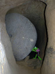
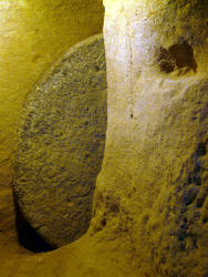
A small part of the caverns was sued to store wine. There are holes in the ceiling, closed by rocks, which were used to throw the grapes into the cellar. A short passage leads to the church, the entrance can be sealed with a millstone door. The apse of the church is hollowed out at the end of the long side and its facade was decorated with carvings.
The rocks around the village are riddled with more caves. Most of them are tombs, the facades decorated with pillars and gables, some are churches. One rock chapel south of the village is well preserved.
 Search DuckDuckGo for "Mazi Underground City"
 Google Earth Placemark
 OpenStreetMap
 Mazi Underground Settlement
 Index
Index Topics
 Hierarchical
 Countries
 Maps
Maps