Tonto Natural Bridge
Useful Information

| Location: |
Tonto Natural Bridge State Park, turn off State Route 87 on FR 583, 16 km north of Payson.
(34.319722, -111.456667) |
| Open: |
All year daily 9-17. Last entry 16. Thanksgiving 9-14. Christmas Eve 9-14. Closed 25-DEC. [2021] |
| Fee: |
Adults USD 7, Children (7-13) USD 4, Children (0-6) free. [2021] |
| Classification: |
 Natural Bridge Natural Bridge
|
| Light: | n/a |
| Dimension: | H=56 m, W=46 m, L=120 m. Cover: H=18 m. A=1,380 m asl. |
| Guided tours: | self guided. V=94.000/a [2007] |
| Photography: | allowed |
| Accessibility: | no |
| Bibliography: | |
| Address: | Tonto Natural Bridge State Park, P.O. Box 1245, Payson, AZ 85547, Tel: +1-928-476-4202. |
| As far as we know this information was accurate when it was published (see years in brackets), but may have changed since then. Please check rates and details directly with the companies in question if you need more recent info. |
|
History
| 1877 | first documented by Scotsman David Gowan. |
| 1893 | David Goodfellow and family emigrate from Scottland to live here. They build a road, a house, and six small guest cabins. |
| 1920s | Goodfellow Lodge, a 10-room lodge with running water, built. |
| JAN-1926 | David Gowan died. |
| 1948 | Gowan family leaves, place is purchased by Glen L. Randall. |
| 1980 | Clifford Wolfswinkle new owner of the site. |
| 1987 | lodge renovated to its original condition. |
| 19-JUL-1990 | Purchase Agreement between the State Parks Board and the Tonto Natural Bridge, Inc., signed. |
| 29-JUN-1991 | Tonto Natural Bridge State Park inaugurated. |
Description
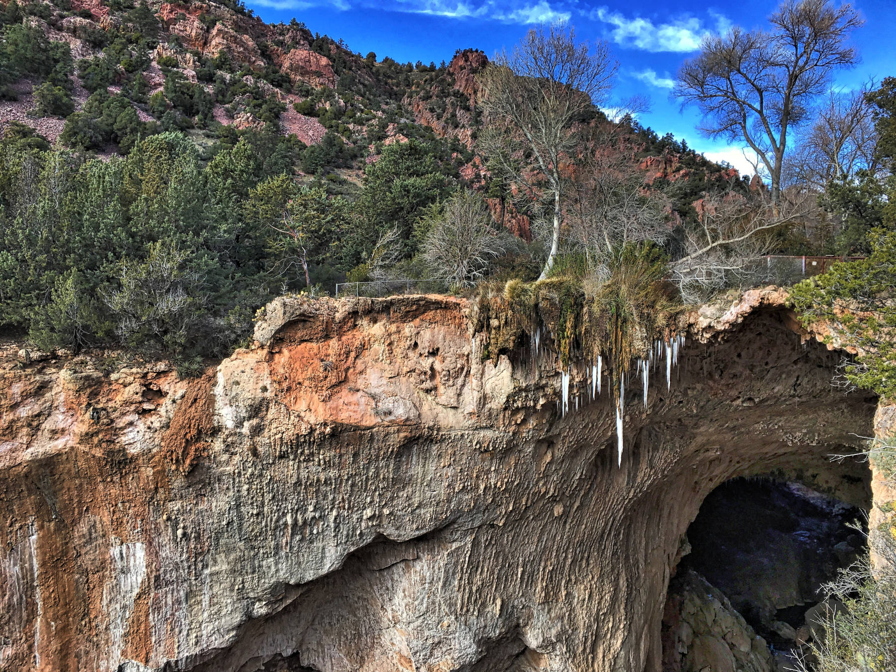
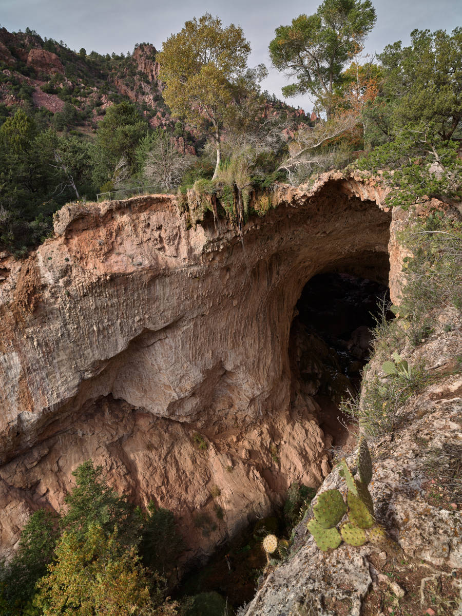
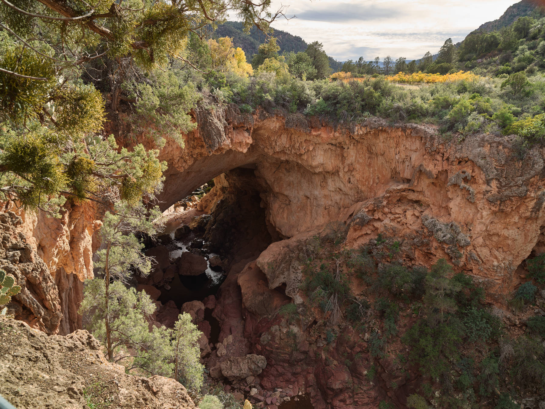
Tonto Natural Bridge is a huge natural bridge, which is probably the biggest natural bridge in travertine. There is actually no official "biggest natural bridge in travertine" list, so we can not be sure, but travertine is actually rather rare and natural bridges in travertine are much rarer. So we believe the claim is correct, but it definitely becomes nonsense if you omit the "in travertine" part, which unfortunately happens now and then.
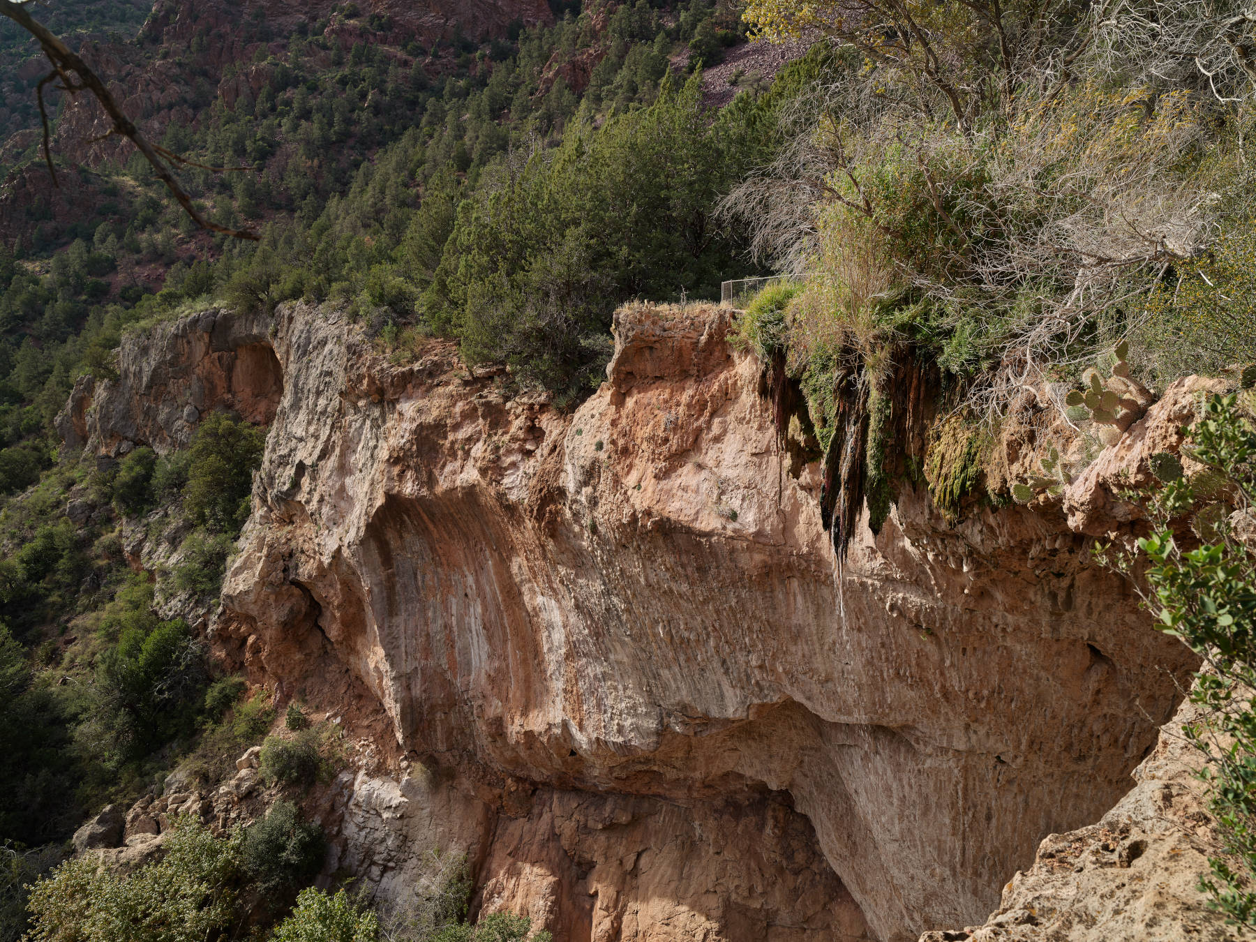
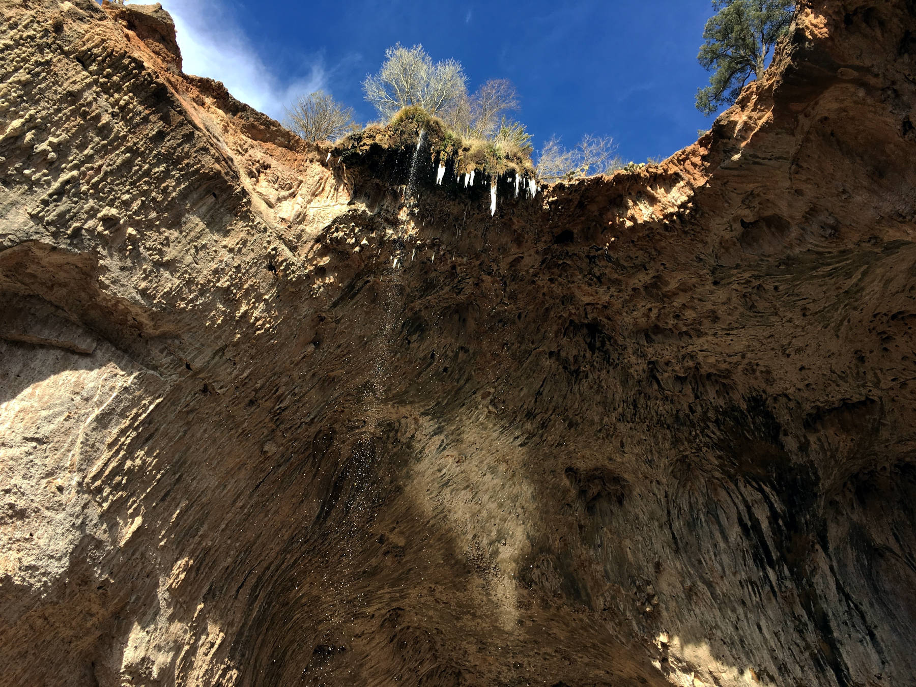
Travertine, tuff, tufa, sweetwater limestone, is a rather young deposit of limestone which was formed by precipitation of limestone from limestone rich water emerging from a spring, most likely a karst spring. Those deposits normally form a sort of plateau with a rim and waterfalls. The limestone is deposited at the rim and the plateau tends to grow around the waterfalls, and as the river on the plateau frequently changes its course, it actually grows into all directions. While it is common that empty spaces are overgrown by tufa and form caves, there is no water flowing inside those caves and they normally have no natural entrance. However, in rare cases there is another river in front of the tufa plateau and the tufa plateau grows towards the river. In most cases its growth will be stopped by this river, but sometimes it "overgrows" the river forming a river cave or natural bridge.
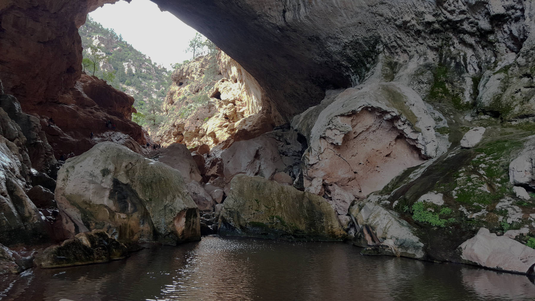
This is what happened here, a huge travertine deposit fed by springs at the valley side fills the valley, with a flat plateau on top, where Visitor Center and parking lots were built. The river Pine Creek, which runs through the valley, stopped the growth of the plateau, except for the southernmost section. Here the travertine reached the other side of the valley and the Pine Creek now flows through a 120 m long natural bridge. Bats do not care about its geologic origin, five species live in the natural bridge: Myotis velifer, Myotis californicus, Myotis lucifugus, Myotis yumanensis, and Euperma maculatum. The park provides habitat for animals, insects, and birds and offers year-round wildlife viewing opportunities.
The bridge was discovered by Scotsman David Douglas Gowan in 1877 while prospecting for gold in the Tonto Rim area. He descended from the mountains to the east to the beautiful little valley and explored the natural bridge and some caves. He decided he wanted to live here, and returned several times, but one day the Indians who used the plateau for planting crops since generations, returned. So he started a sort of "war" about the property he had claimed, but which actually belonged to the Apaches. Its unclear how he actually gained ownership, but obviously the original owners were not very happy they were robbed. In the interest of preserving his life, it became necessary to hide for three days and nights in one of the deep caves under the Bridge until the Apache’s war fever subsided. He used the flat land on top of the travertine to plant walnut, apricot, peach, apple, cherry and pear trees. On one of his trips for provisions he met an Englishman and told him about his natural bridge. As a result the Englishman dispatched a story from Phoenix about the “secondstory farm” atop a large Natural Bridge in Arizona. David Goodfellow, a nephew of David Gowan, read this article in a Scottish newspaper. Wondering if this could be his “long lost” uncle, he wrote a letter addressed “David Cowan, near Flagstaff, Arizona Territory, United States of America”. The U.S. Postal Service was actually able to deliver the letter correctly. Gowan who had grown tired of his lonely life, offered to his nephew in Scotland to come to America and settle here. David Gowan died in January 1926 well over 70 years old. Deputy sheriff Jim Kline on his regular two week’s visit found his little cabin empty. He searched the area and found the body in Deer Creek, and buried the remains right beside the creek. The Gowan family lived at this place until 1948, their lodge building is included in the National Register of Historic Places. In 1948 the area was purchased by Glen L. Randall from Pine, Arizona, together with his father Walter Randall and a brother. After Randall’s death in 1967, his wife Eloise Kleinman Randall sold the property to the State and the State Park was established.
There are several well developed trails to see the bridge. At the end of the Bridge Lot you are almost on top of the bridge, which looks like a flat meadow from here. The upper opening is on the right hand side, the lower on the left. On both sides are two lookouts, one on each side of the opening, which offer great views. They are accessible on a level and paved walking path and are wheelchair accessible. If you want to see the bridge from the ground of the gorge, there is a trail on each side which leads down. On the left side the Gowan Trail is 500 m long (one way) and leads to the lower opening of the bridge. It ends with an elevated plankway, a bridge across the river, and a wooden observation deck. You must return on the same trail.
On the right side is Anna Mae Trail, which is 300 m long and leads to the upper opening of the bridge. Here it meets with Pine Creek Trail and Waterfall Trail. Pine Creek Trail is the longest trail and starts at the Pine Creek & Waterfall Trail Lot, the first on the right side when you enter the park. It follows the valleay first upstream, the descend very slowly to the river and then follows the Pine Creek river downstream. Waterfall Trail is a sort of shortcut, starting at the other end of the parking lot and leading down very steep to meet Pine Creek Trail midway. On the way you can see a waterfall, hence the name, and see the formation of tufa firsthand. Pine Creek is 600 m long and Waterfall 400 m. We recommend to walk down Anna Mae Trail, go to the bridge, then walk back on Pine Creek Trail upstream and take Waterfall Trail back up to the parking lots. Such a roundtrip is about 1.2 km long, more or less 20 minutes walk, but due to the ascend and the sightseeing you should plan at least an hour.
It is not possible to walk through the natural bridge, and park rules do not allow swimming and wading under the natural bridge, or leaving the trails at all for that matter. But from the upper end it is at least possible to walk a short distance into the bridge. On the Gowan Trail the platform is in front of the portal. Wear appropriate walking shoes, use sun protection, especially a hat, and take some water with you. Glas containers are forbidden.
 Search DuckDuckGo for "Tonto Natural Bridge"
 Google Earth Placemark
 Tonto Natural Bridge - Wikipedia (visited: 17-MAY-2021)
 Tonto Natural Bridge State Park (visited: 17-MAY-2021)
 Index
Index Topics
 Hierarchical
 Countries
 Maps
Maps