Aareschlucht
Useful Information


| Location: |
Between Innertkirchen and Meiringen.
From Bern take A6 freeway to Thun, then A8 freeway to the end. It becomes highway 6 along the Aare river to Meiringen. Follow signs. Aareschlucht West: (46.720199, 8.204998) Aareschlucht Ost: (46.712111, 8.216485) |
| Open: |
West: 02-APR to mid-JUN daily 8:30-17:30. 12-JUN to mid-SEP daily 8:30-18:30. JUL to AUG Fri, Sat 18:30-22. Mid-SEP to 01-NOV daily 8:30-17:30. East: 13-MAY to mid-JUN daily 8:30-17:30. 12-JUN to mid-SEP daily 8:30-18:30. Mid-SEP to 01-NOV daily 8:30-17:30. [2021] |
| Fee: |
Aare Gorge: Adults CHF 10, Children (6-16) CHF 6, Children (0-5) free. Groups (10+): 1 free admission, Teachers on school trips free. Gorge with Reichenbach Falls: Adults CHF 18, Children (6-16) CHF 13, Children (0-5) free. Reichenbach Falls: Adults CHF 12, Children (6-15) CHF 8, Children (0-5) free. [2021] |
| Classification: |
 Gorge Gorge
|
| Light: |
 Electric Light
Coloured Light Electric Light
Coloured Light
|
| Dimension: | L=1,400 m, W=1 m. |
| Guided tours: | self guided, L=1,650 m (one way), D=45 min (one way). |
| Photography: | allowed |
| Accessibility: | partly, from the west entrance, not in JUL and AUG. Only narrow and light wheelchairs and strollers. |
| Bibliography: |
René Hantke, A. E. Scheidegger (1993): Zur Genese der Aareschlucht (Berner Oberland, Schweiz), September 1993, Geographica Helvetica 48(3):120-124 DOI researchgate Franz Müller (1938): Geologie der Engelhörner, der Aareschlucht und der Kalkkeile bei Innertkirchen, Beitr. geol. Karte Schweiz, N.F. 74, 55 pp. Peter Heitzmann, Marta Falke (1992): Eine Strasse durch die Aareschlucht?, Ein geotechnisches Gutachten aus dem Jahre 1811. Bulletin der Vereinigung Schweiz. Petroleum-Geologen und - Ingenieure, Vol. 59, Nr. 134, Juni 1992 - S. 27-35 pdf |
| Address: |
Aareschlucht AG, 3860 Meiringen, Tel: +41-33-9714048,
E-mail: |
| As far as we know this information was accurate when it was published (see years in brackets), but may have changed since then. Please check rates and details directly with the companies in question if you need more recent info. |
|
History
| 1779 | visited by Johann Wolfgang von Goethe. |
| 28-SEP-1887 | the village Willigen gets the concession to build a path through the gorge. |
| 1888 | path opened to the public. |
| 1889 | additional galleries to the Finsterer Schlauch and Lammi completed, entrance building with ticket office added. |
| 1895 | Grimsel Paß road completed and opened, which results in an increase of visitors. |
| 1898 | gallery to eastern entrance built. |
| 1912 | electric light for the night installed, tram Meiringen - Reichenbach - Aareschlucht opened. |
| 1928 | restaurant and kiosk at the west entrance built. |
| 1942 | flood destroys most of the paths. |
| 1947 | Susten road opened, enormous increase of visitor numbers. |
| 1957 | tram closed. |
| 1987 | restaurant and kiosk at the western entrance renovated. |
| 2003 | railway station and suspension bridge built at the eastern entrance. |
| 2008 | kiosk and bistro built at the eastern entrance. |
Description


The Aareschlucht (Aare River Gorge, Aare Gorge) is the only way into the upper Aare valley, called Haslital. It is the original connection between the two villages Innertkirchen and Meiringen. Today there is a road across the Kirchet, the mountain ridge around the gorge, which blocks the valley. It is also called Querriegel (crossbeam), which is not a name but an old term which expresses that it runs across the valley and block it.
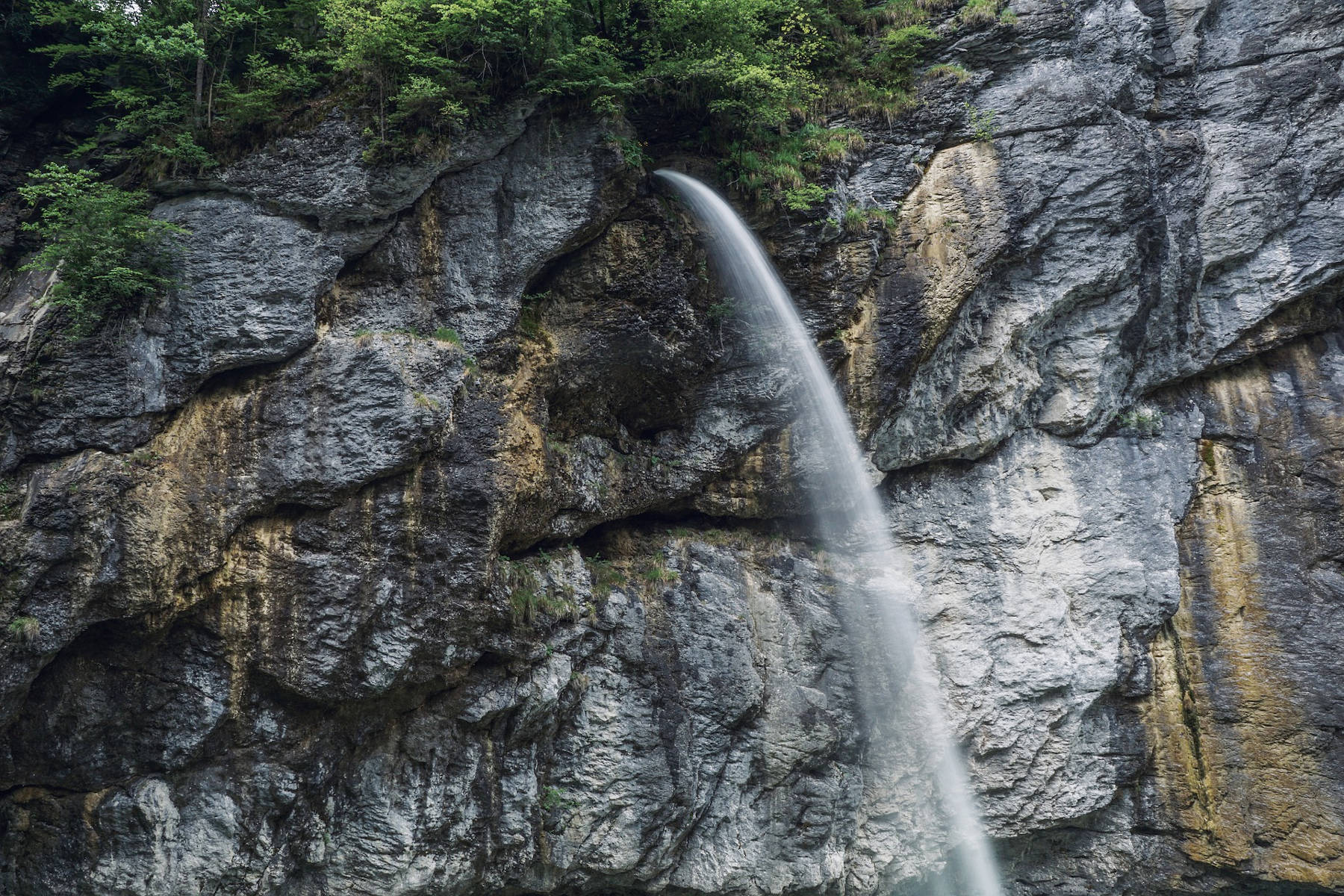
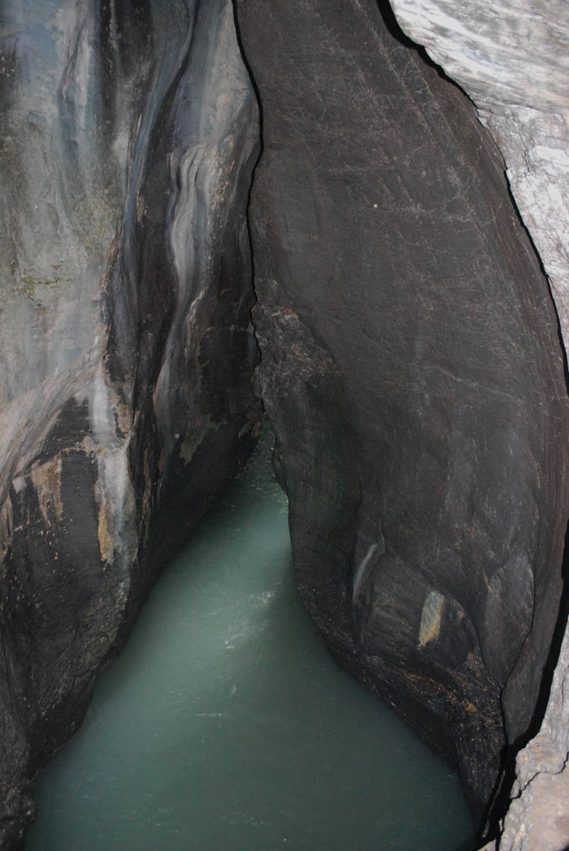
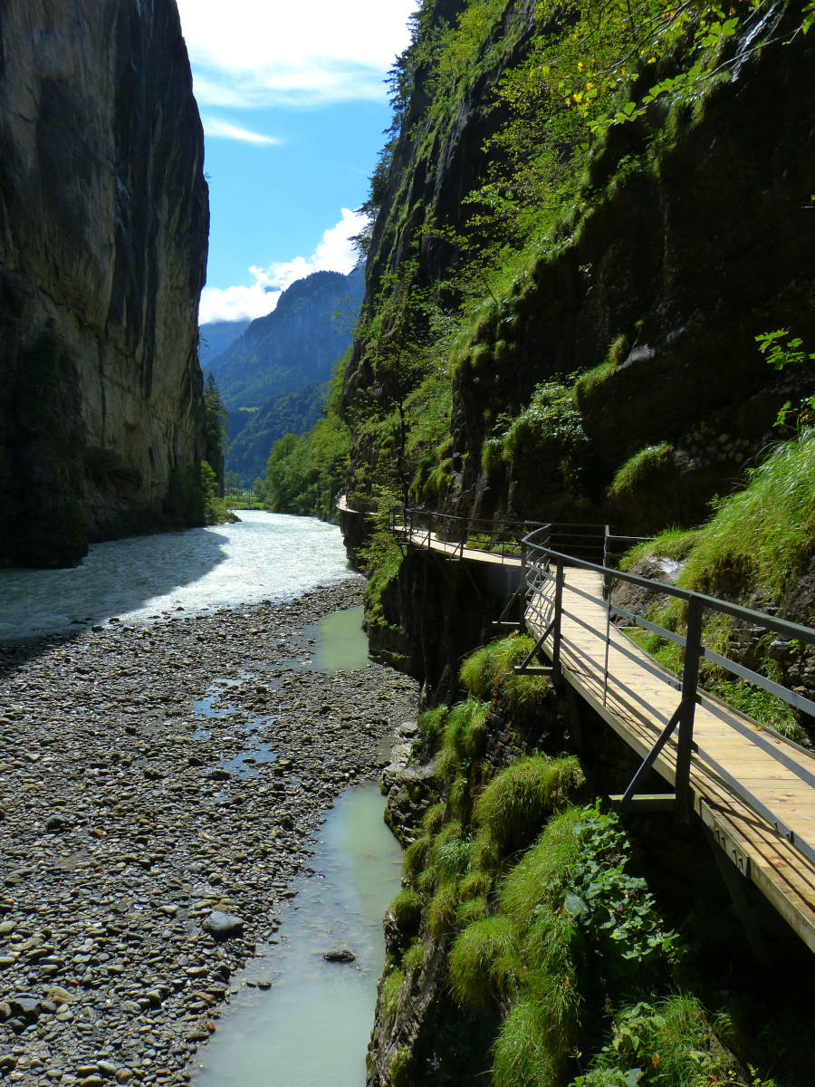
The Aare river is fed by rainwater and melting water from the Alps, and here it already has a decent size. The river is about 30 m wide and quite fast flowing. But the gorge is much narrower, typically about 10 m wide, and as a result the water flows faster and is quite deep. And if there is heavy rainfall in the catchment area or in spring during snowmelt the river has much more water and the level inside the gorge rises substantially. For this reason the trail is built rather high on the wall, otherwise it would be destroyed almost every year. Bring a raincoat and/or umbrella, because the gorge has many wet spots, where small waterfalls hit the trail. The tunnels and darker galleries are electrically lit. During July and August on weekends the gorge is open in the evening, which is called Aareschlucht by Night. At this time not only the passages but also the gorge is lighted, partly with coloured light.
The gorge was cut by the river into hard Cretaceous limestones. The Kirchet is a section of the sedimentary rocks which was moved during the alpine orogeny (in the last 10 Million years) but not folded. Bending creates numerous cracks in the brittle rock, which makes it permeable and thus less resistant to weathering. But this block was not folded and is thus resistant against erosion. The ridge blocking the valley is of glacial origin and rather young. The ice ages started about 2.4 Million years ago and the valley filled with a glacier. The moving glacier eroded the rocks and deepened the valley, less resistant rocks were eroded more easily and thos sections are deeper. In the next warm period the higher parts dammed the flowing water and the lower parts filled with water. The river flowing out of the lake above, across the Kirchet, cut deep into the limestone forming a gorge which finally drained the lake.
The ice ages are a sequence of cold and warm times, during cold times, which lastend around 100,000 years, the valley was filled with a glacier. The warm times between were much shorter. The gorge which formed in the first warm period was filled by moraine, gravel from the glacier, during the next cold period. In the following warm period the water found a new way and cut a new gorge. In other words, a new gorge was formed in any warm period. Geologists identified four traditional cold ages in the 19th century, but modern isotope based methods revealed many more. At the Kirchet five more gorges could be identified by Franz Müller in the 1930s. However, it was not possible to date the gorges, so it is unknown which formed in which warm age. The current gorge formed during the last 10,000 years in the current warm age.
The gorge is about 1,400 m long, up to 180 m deep and the narrowest sections are only 1 m wide. There are 1,650 m of path through the gorge, only 250 m are normal trails built on the ground. About 400 m are cut out of the rock, either as galleries or as tunnels. About 1,000 m are bridges built of steel with wooden floor and railing, which were mounted on the vertical wall, high above the river. The most impressive entrance is the west entrance, where you enter the gorge through the ticket office and a long tunnel, just to stand in the middle of the narrowest part of the gorge.
Probably the strangest thing with the Aareschlucht is the train station Aareschlucht Ost. In the rock is an elevator door, which opens for train passengers. They are transported down to the underground train station inside the tunnel which allows the train to cross the Kirchet. The local train stops only, if someone on the train or in the train station requests this by pressing a button, which is common on trams but exceptional on normal trains. There are train stations on both ends of the gorge, so it is easy to combine the visit with a train ride, or walk the gorge one way and return by train to the car.
 Search DuckDuckGo for "Aareschlucht"
 Google Earth Placemark
 Aareschlucht - Wikipedia (
 )
) Die Aareschlucht, official website (
 )
) Index
Index Topics
 Hierarchical
 Countries
 Maps
Maps