Klausenhöhlen
Useful Information


| Location: |
93343 Essing.
(48.9344962, 11.7842145) |
| Open: |
APR to SEP no restrictions. [2025] |
| Fee: |
free. [2025] |
| Classification: |
 Karst Cave Karst Cave
|
| Light: | bring torch |
| Dimension: | L=330 m, A=380 m NN. |
| Guided tours: | self guided |
| Photography: | allowed |
| Accessibility: | no |
| Bibliography: |
Gisela Freund (1961):
Zur Frage paläolithischer Besiedlung der Unteren Klause bei Neu-Essing, Landkreis Kelheim,
Germania Bd. 39 Nr. 1/2 (1961).
online
DOI

Christian Züchner (2008): Die Klausenhöhlen bei Neuessing. Landkreis Kelheim In: Hugo Obermaier-Gesellschaft (Hrsg.): 50. Jahrestagung in Erlangen. PrintCom, Erlangen 2008, ISBN 978-3-937852-02-7.
Michael Rind, Ruth Sandner (2008): Klausenhöhlen – Schutz für altsteinzeitliche Jäger und Sammler In: Archäologiepark Altmühltal: Ein Reiseführer in die Vorzeit. Schnell und Steiner, Regensburg 2008, ISBN 978-3-7954-2106-9, S. 61–67.
Detlef Mikeska, Martin Trappe, Helmut Miedaner (2010): Die Klausenhöhlen bei Essing In: Karst und Höhle 2008–2010. Südliche Frankenalb – Region Altmühl- und Donautal. München 2010.
|
| Address: | Gemeinde Essing, Herr Jörg Nowy, Marktplatz 1, 93343 Essing, Tel: +49-9447-920093. |
| As far as we know this information was accurate when it was published (see years in brackets), but may have changed since then. Please check rates and details directly with the companies in question if you need more recent info. |
|
History
| 1860 | Untere Klause is cleared out for use as a beer cellar, Klausennische is used as a beer garden. |
| 1900-1908 | excavations by local researcher Joseph Fraunholz. |
| 1908 | Wiedemann brewery from Neuessing wants to set up a "Grotten-Schänke" in the Obere Klause. |
| 1912-1913 | Further excavations by Hugo Obermaier (Institut de Paléontologie Humaine, Paris), Ferdinand Birkner, Joseph Fraunholz, Gero von Merhart and Paul Wernert. |
| 04-OCT-1913 | Hugo Obermaier, Paul Wernert and Ferdinand Birkner discover a burial pit. |
| 2018 | excavations by Prof. Th. Uthmeier and Dr. A. Maier from the Institut für Ur- und Frühgeschichte of the FAU Erlangen. |
Description

The Klausenhöhlen (Klausen Caves) are a group of three karst caves called the Untere Klausenhöhle (Lower Klausen Cave), the Obere Klausenhöhle (Upper Klausen Cave) and the Westliche Klausenhöhle (Western Klausen Cave) as well as a shelter called the Klausennische (Klausen Niche). So it seems that the plural is justified, but in fact the caves are connected to each other except for the Klausennische, so there is only one. This cave system has four different levels, between 22 m and 55 m above the Altmühl. They are located on the right-hand slope of the Altmühl valley, opposite the village of Essing. There is a car park on the through road of Essing, from where you can cross the Altmühl on a wooden bridge called Tatzlwurm. A hiking trail uphill and along the slope leads to the Klausen Caves in about 20 minutes.
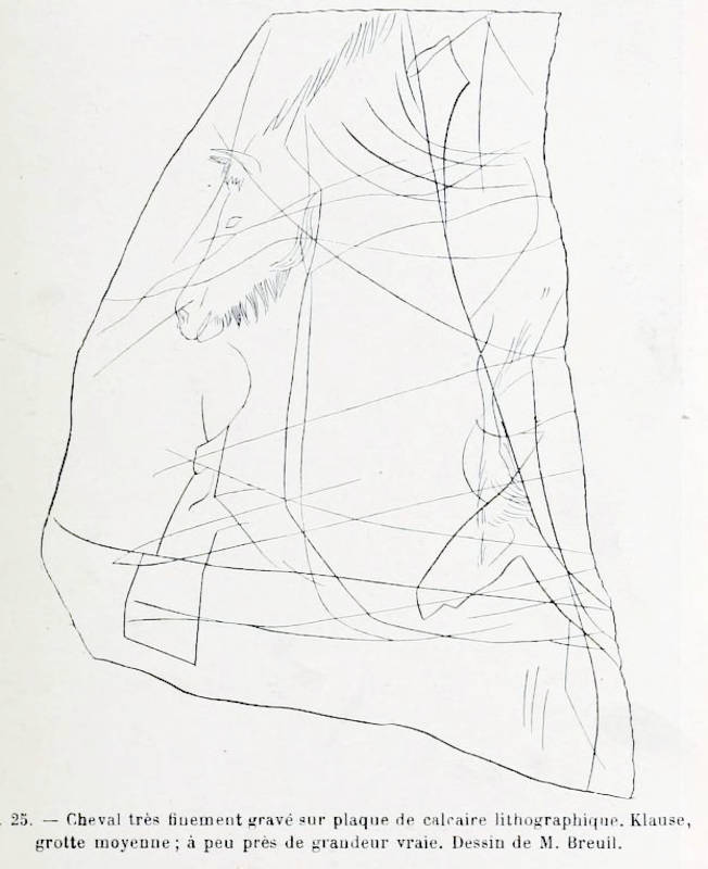
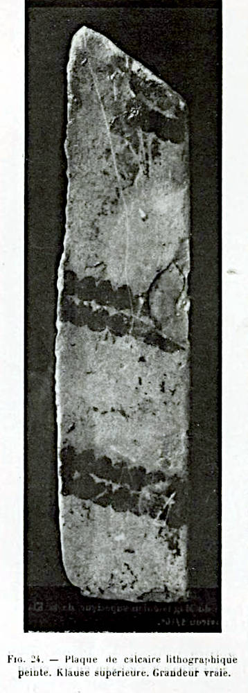
The Klausen caves are located on a slope, during the ice age the valley slopes were grassy, and you had a good view of game travelling through the valley, so this was an ideal hunting station. The disadvantage, however, was the location on the northern slope, but the cave was still visited for a long time. Most of the artefacts date back to the Palaeolithic period, and the Klausen Caves are one of the most important Ice Age sites in Bavaria. The oldest burial of an anatomically modern human (Homo sapiens) in Germany was excavated. Various Neanderthal and Cro-Magnon man finds were made, including hand axes, blades, scrapers, hand points and burins. The material was flint, bone and teeth. Engravings of a wild horse’s head and a mammoth were also found.
The Obere Klause is quite an impressive chamber, 27 m long and 15 m wide, up to 5 m high. Despite the disturbance caused by tourist use, considerable finds from the Magdalenian period have been made here. The Mittlere Klause is a low hall 21 m long and 18 m wide. The layers here were already mixed during the excavation; it is not known how this came about, but it can be assumed that the cave was used as a cellar or something similar. The Untere Klause was already cleared out in 1860 for use as a beer cellar, and only a few finds were made in niches in the wall. Nevertheless, a strongly s-shaped, curved fragment of a collarbone, possibly from a Neanderthal, was found here. The Klausennische is an abri or shelter which is 5 m wide and 3 m high. A beer garden was set up here in 1860, destroying most of the artefacts. A human tooth found here was identified by Wolfgang Abel in 1936 as the milk incisor of a Neanderthal child.
Archaeological exploration of the caves began as early as 1900 by local researcher Joseph Fraunholz. The amateur archaeologist and full-time Rentamtmann (rent officer) had already made a great contribution to the exploration of many sites in the Naab and Altmühltal valleys. He created a stratigraphy in niche B of the Obere Klause. In 1908, the Wiedemann brewery from Neuessing wanted to set up a „Grotten-Schänke“ ("grotto pub") in the Obere Klause. To this end, they carried out several excavations, destroying valuable layers of artefacts in the process. However, Prof. Ferdinand Birkner was present and recognised layers from the late Würm glacial period (Magdalenian) as well as shards and bones from the upper Holocene layers.
Further excavations by Hugo Obermaier (Institut de Paléontologie Humaine, Paris), Ferdinand Birkner, Joseph Fraunholz, Gero von Merhart and Paul Wernert took place in 1912 and 1913. A Late Palaeolithic burial was discovered in the Mittlere Klause. The burial pit had been dug 20 cm deep into the older Moustérian layer. It contained a relatively complete male skeleton of an anatomically modern human (Cro-Magnon man). It was embedded in a dense red chalk pack, a typical burial custom of the Upper Palaeolithic, in a rock crevice. Radiocarbon dating of a vertebral bone yielded an age of 20,269±439 BC, which is before the beginning of the Magdalenian period in Central Europe. The man was about 30-40 years old.
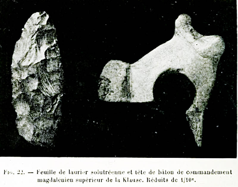
Another often cited find is called the Kommandostab (command staff). This is a "bâton de commandement", which in German is known as a Lochstab (perforated baton) or Kultstab (cult staff), while the english term is actually perforated baton. Perforated batons are usually made from the shafts of reindeer or red deer, are smoothed, decorated with incisions and have the characteristic hole. The intended use is unclear, but at the time of Hugo Obermaier, it was still vaguely assumed to be merely decorative and a kind of sceptre. As Obermeier worked at the Institut de Paléontologie Humaine and published there in French, he used this term, which was then translated literally. More recent research assumes a tool, either as an extender of spears and arrows, whereby curved antler poles or wood are straightened over fire and water vapour. Another theory assumes that straps were pulled through the hole with oil to make them more elastic. The use as a tent peg, a fibula or for twisting fibres into a rope has also been discussed. And finally there is the nose brake, a loop of rope runs through the hole around the animal’s upper lip, when the animal struggles it pulls and causes slight pain. This seems to be the most likely theory, the Palaeolithic perforated batons correspond to the modern ones. The perforated batons can be seen in the picture on the right, it is only a fragment of the head, but the hole is clearly visible.
The excavations from the beginning of the 20th century are relatively poorly documented, even for the time. In the meantime, archaeology has developed further and a variety of investigation methods have been developed. In 2018 and 2019, under the direction of Prof. Th. Uthmeier and Dr A. Maier from the Institute of Prehistory and Early History at FAU Erlangen, excavations were carried out again after a century. Among other things, the remains of the previous excavation were analysed in order to obtain background information about the finds at the time. From today’s perspective, the documentation at the time was very inadequate. The Klausen niche was also excavated, using OSL dating, micromophological analyses, C14 dating and Zooarchaeology by Mass Spectrometry (ZooMS). However, most of the contents of this cave have been destroyed in recent centuries, or at least too heavily disturbed to be of interest, so the other caves and abris in the area are of much greater importance today.
The caves are very well developed with a comfortable hiking trail, stairs and even signposting. We definitely recommend hiking clothing, hiking boots and a torch. Like all caves with bats, this one is closed in the winter months to protect bats, and there is even an iron gate.
- See also
 Search DuckDuckGo for "Klausenhöhlen"
 Google Earth Placemark
 OpenStreetMap
 Klausenhöhle - Wikipedia (visited: 06-AUG-2025)
 Klausenhöhlen Essing (visited: 06-AUG-2025)
- Klausenhoehlen / Essing (visited: 12-AUG-2025)
- Ausgrabungen in den Klausenhöhlen bei Essing (visited: 12-AUG-2025)
- Die Klausenhöhlen bei Neuessing by Franz Lindenmayr (visited: 12-AUG-2025)
 Index
Index Topics
 Hierarchical
 Countries
 Maps
Maps