Ellenville Fault Ice Caves
Ice Caves Mountain - Ice Caves of the Shawangunks - Ellenville Ice Caves
Useful Information

| Location: |
Sam’s Point Area, Minnewaska State Park Preserve.
Near Ellenville, Ulster County, NY. (41.672446, -74.346040) |
| Open: |
Ellenville Fault Ice Caves:
no restrictions. Shingle Gully: permit required. Conservation Center: Mid-APR to mid-NOV daily 9-5. [2022] |
| Fee: |
Ellenville Fault Ice Caves:
Vehicle Use Fee USD 10, Bus Non-profit USD 60, Bus Commercial USD 100. Shingle Gully: permit required. [2022] |
| Classification: |
 Spaltenhöhle
ice cave
Silurian rocks Spaltenhöhle
ice cave
Silurian rocks
|
| Light: | bring torch, solar-powered led |
| Dimension: | |
| Guided tours: | self guided. D=3 h. |
| Photography: | allowed |
| Accessibility: | no |
| Bibliography: |
Meghan Kirkpatrick (2006):
Shingle Gully Ice Caves Management Plan: Balancing Recreational Use and Senstive Ecosystem Protection,
Middle States Geographer, 2006, 39:52-60.
pdf
William R. Halliday (1954): Ice Caves of the United States, The American Caver – Bulletin of the National Speleological Society, v. 16, no. 12, p. 3–28. |
| Address: |
Minnewaska State Park Preserve, Sam’s Point Area, 400 Sam’s Point Road, Cragsmoor, NY 12420, Tel: +1-845-647-7989.
Contact for a permit: Victoria Latini, Guest Services Assistant, Tel: +1-845-647-7989-100. E-mail: |
| As far as we know this information was accurate when it was published (see years in brackets), but may have changed since then. Please check rates and details directly with the companies in question if you need more recent info. |
|
History
| NOV-1967 | designated a National Natural Landmark. |
| 1960s-1990s | Sam’s Point privately owned and operated as a tourist attraction. |
| 1997 | purchased by the Open Space Institute (OSI), operated by the Nature Conservancy. |
| 2015 | Minnewaska State Park created. |
Description
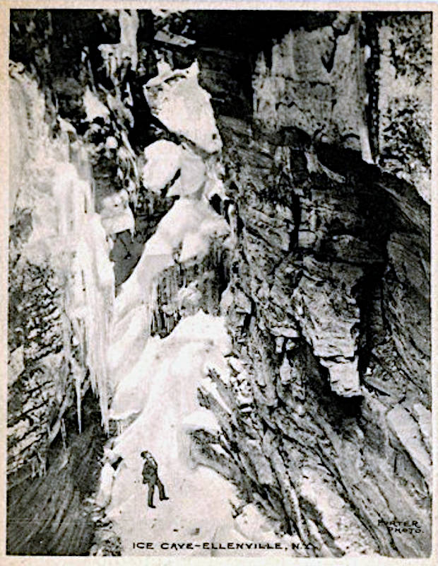
The Ellenville Fault Ice Caves are actually a long crack in the sandstone surrounded by some small side cracks. As the main crack, has almost vertical walls and there is no opening at the bottom, the hole in the ground forms a cold trap. Cold air is heavier than warm air, so in winter the cold air flows into the gorge and in summer the cold air stays in the gorge, trapped. This natural effect is also called cold trap and is used for deep freezes in supermarkets, which work well, even if they have no lid. Rainwater, groundwater, and snow form a layer of ice on the floor which remains in the cracks until late summer, depending on the year. Finally, the ice melts away, but the caves are pretty cold around the year. In some remote parts the ice stays the whole year.
The cave itself is of a very rare type of caves: a so called
fracture cave.
It was formed as a part of the mountain pulled away at a crack or fracture, sliding on a bedding plane or another fracture, creating a straight ravine.
Large blocks of Silurian rocks, quartz sandstones and conglomerates, slid along fractures and bedding surfaces.
Some brochures say it is the "largest open fault in the United States with corresponding ice caves".
That’s obvious nonsense, the accurate point is, it’s the largest known exposed fault system (American for fracture cave) in the United States.
The caves are located in the Minnewaska State Park Preserve. From Ellenville follow Sams Point Road to the Sams Point parking lot and Visitor Center. From here it’s a 7 km roundtrip to the caves and back, if you add some time for the outlooks and for visiting the caves, the whole trip might take three hours. The trails lead uphill to an escarpment which is called Sams Point and offers great views. Once on top of the Shawangunk Ridge, there is a paved road across the plateau, which is for some reason called a carriageway. The caves are on the opposite side of the plateau.
The Ellenville Fault Ice Caves are actually a gorge, and not really a cave, as it has no roof. They are named after nearby village Ellenville and the fault which formed them. However, during the last decades they had numerous other names, which seem to be uncommon now. They were called Ice Caves Mountain, Commercial Ice Caves, and Ice Caves of the Shawangunks, after the name of ridge. In the mid 20th century the Ice Mountain Caves were operated as commercial caves, the American term for show cave. At that time the road was open and the still existing parking lot was in use. People came to the caves by car, paid an entrance fee of $6.50, and visited the caves on wooden trails. Then they continued on the loop road to Sams Point and stopped at the parking lot there for the view.
While the paved road and even some wooden trails still remain, the ticket office and entrance fees are gone. There was also at least one cave which was entered through a big wooden door, obviously to keep the cold air inside. And the worst: the caves were illuminated by multicolored flood lights. Since the 1990s, the caves have been restored to their natural appearance, only some ladders, railings, and solar-powered lights are a reluctant concession to ensure visitor safety. We had the site listed as a show cave under the name Ice Caves Mountain. So if you check the waybackmachine you will find this page as Ice Caves Mountain in the show caves section.
There are actually two groups of caves, which are almost 5 km apart. The first group is the one which was a commercial operation and is today part of the trail. The other group is 4.8 km to the northwest and is called Shingle Gully Ice Caves. It is also known under various names, like Ellenville Ice Caves, Cave of Mists, Greater Ice Caves, Greater Ellenville Ice Caves, and Noncommercial Ice Caves. The last name, Noncommercial Ice Caves, is because the caves at Shingle Gully were never open as commercial caves and was common while Ice Caves Mountain were in operation. All cracks together are 500 m long, the main crack about 250 m long and up to 40 m wide and deep.
You can hike the 5 km across Shawangunk Ridge, but the best way to reach them is from the end of Mine Lane in Ellenville. The road continues as a single lane gravel road which is called Smiley Road. After a kilometer it becomes a walking trail, after 500 m there is a trail to the right and after 500 m more you reach Shingle gully. Both lead uphill to the ice caves, after 800 m you have reached the first caves. We have linked a different route on wikiloc below. However, the whole area is now part of Minnewaska State Park Preserve and there are no official trails, so for this walk you need a permit. There are official guided tours offered by the Park, which are currently discontinued due to Covid-19 [2022]. Some publications say, the area is only accessible on such tours, others you need a permit from Nature Conservancy. You should probably contact the Visitor Center at Sam’s Point first.
Due to the climatic specialties, the area of the caves has rather strange flora and fauna. Numerous northern and alpine plants such as black spruce (Picea mariana), goldthread (Coptis trifolium), mountain ash (Sorbus americana), hemlock, rowan, and creeping snowberry (Gaultheria hispidula), and bryophytes such as Isopterygium distichaceum can be found. The caves contain a species of cave-dwelling crustacean (Stygobromus allegheniensis). This tiny arthropod survives being frozen, a necessary attribute for surviving winter conditions in the caves. The small reserve is home to nearly 40 rare plants and animals. More than 200 species of migratory and nesting birds can be seen.
- See also
 Search DuckDuckGo for "Ellenville Fault Ice Caves"
 Google Earth Placemark: Ellenville Fault Ice Caves
- Google Earth Placemark: Shingle Gully
 Sam’s Point Preserve - Wikipedia (visited: 15-FEB-2022)
 Minnewaska State Park Preserve: Sam’s Point Area, official homepage (visited: 14-FEB-2022)
- The Ellenville Fault Ice Caves – A National Natural Landmark (visited: 15-FEB-2022)
 Ellenville Fault Ice Caves - Atlas Obscura (visited: 15-FEB-2022)
- Ellenville Ice Caves & Shingle Gully (visited: 15-FEB-2022)
 Index
Index Topics
 Hierarchical
 Countries
 Maps
Maps