Pießling Ursprung
Useful Information
| Location: |
Roßleithen 54, 4575 Roßleithen.
At Roßleithen, near Spital am Pyhrn. A9 motorway exit 48 Windischgarstein, B138 towards Altenmarkt, at Pichl first right to Roßleiten. Car park at Gasthof zum Sengschmied in Roßleithen, 20 min walk. (Katasternummer: 1636/3) (47.6914382, 14.2758669) |
| Open: |
no restrictions. [2025] |
| Fee: |
free. [2025] |
| Classification: |
 Vauclusian Spring Vauclusian Spring
 Karst Cave.
Dachsteinkalk, Triassic limestone (200 Ma). Karst Cave.
Dachsteinkalk, Triassic limestone (200 Ma).
|
| Light: | n/a |
| Dimension: |
Yavg=2,000 l/s, Ymax=38,000 l/s, Ymin=300 l/s, A=710 m üA. Catchment area: AR=95 km². Cave: VR=80 m, L=1,500 m. |
| Guided tours: | self guided |
| Photography: | allowed |
| Accessibility: | no |
| Bibliography: |
W. Buchbauer (1978):
Pießling Ursprung,
Mitteilungen des Vereines für Höhlenkunde Sierning, 1978(1): pp 5-8.

Karl Trotzl, Gerd Teimer (1962): Erster Tauchereinsatz im Pießlingursprung (Oberösterreich), Die Höhle, 13 (4): pp 84-88. pdf
Robert Seebacher (2002): Tauchgang im Endsiphon des Pießling-Ursprung, Tauchgang im Endsiphon des Pießling-Ursprung (1636/3) Roßleithen, Oberösterreich In: Die Höhle – Zeitschrift für Karst- und Höhlenkunde. Band 55. Verband Österreichischer Höhlenforscher, Wien 2004. pdf
Josef Rohrhofer (1970): Naturkundliches Wanderziel in Oberösterreich: Der Pießling-Ursprung, Apollo, Heft 20: 1970, 9-10, Linz. pdf
|
| Address: |
Gemeinde Roßleithen, Pichl 22, 4580 Windischgarsten, Tel: +43-7562-5230-0.
E-mail: |
| As far as we know this information was accurate when it was published (see years in brackets), but may have changed since then. Please check rates and details directly with the companies in question if you need more recent info. |
|
History
| 1911 | Inspektor Georg Lahner (Linz) crosses the spring and explores the upper dry cave passage. |
| 1962 | first dives by W. Fuchs and G. Teimer in the water cave reach a depth of 52 m. |
| 1975 | cave divers from Linz and from the Tauchklub Delphin revive research. |
| 1977 | water pumped out of a side passage, and an 1,000 m long dry branch discovered. |
| 1978 | declared a natural monument. |
| 11-OCT-1987 | a female cave diver dies in an accident, another diver who tried to rescue her dies too. |
| 26-MAR-2002 | exploration of the end siphon by Robert Seebacher. |
| 2024 | new viewing platform opened. |
Description
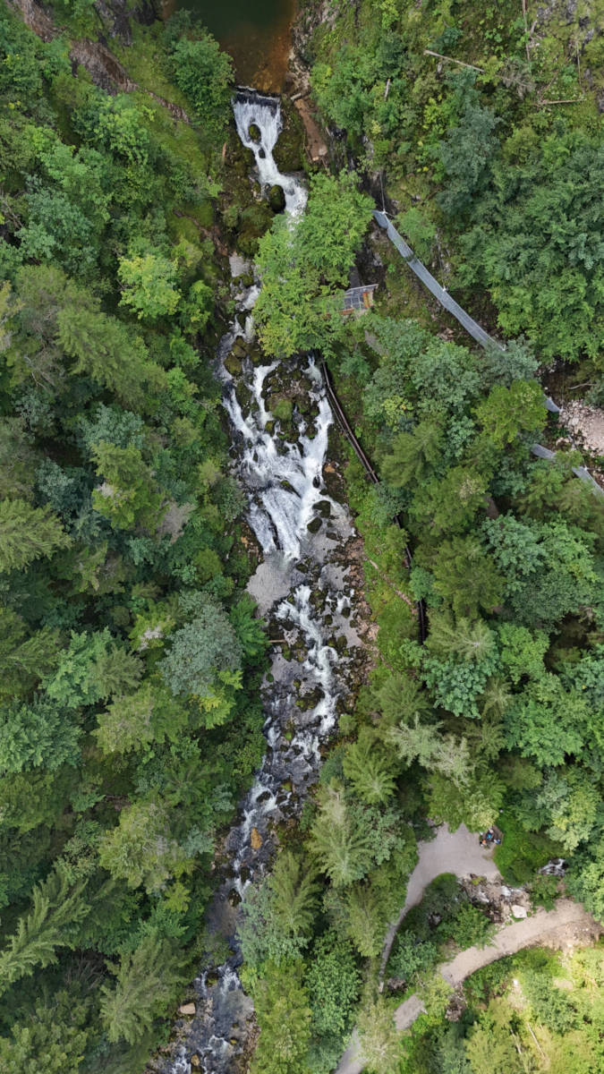
The name Pießling Ursprung means spring of the river Pießling. It is one of the largest karst springs in Austria, with a Yield of up to 38,000 l/s during snow melt. The normal flow rate is around 500 l/s in winter and up to 2,000 l/s in summer; even in extremely dry conditions, the flow rate never falls below 300 l/s. Such fluctuations in flow are characteristic of karst springs. It drains an area of some 95 km² which is called the Warscheneckstock, a part of the Totes Gebirge, a famous karst area with many huge caves. The main peak of this massive is also called Warscheneck (2,388 m asl). The Pießling-Bach (Pießling river) is only seven kilometers long. It is a tributary of the Teichl, then Steyr, Enns and finally the Danube, which flows into the Black Sea.
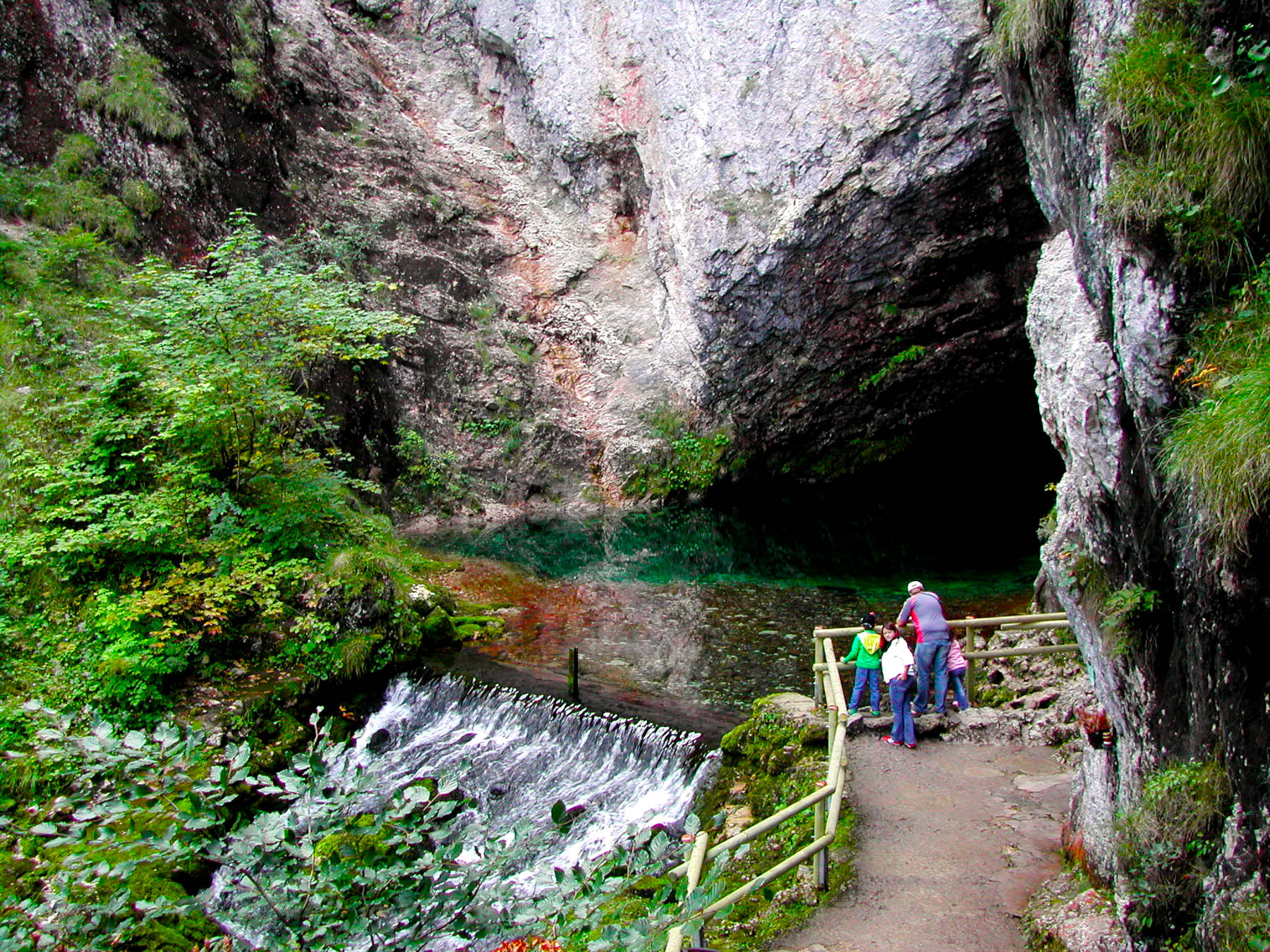
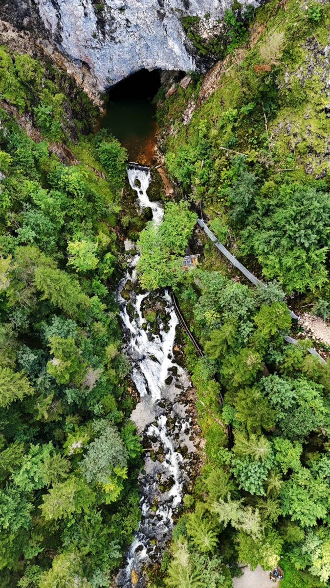
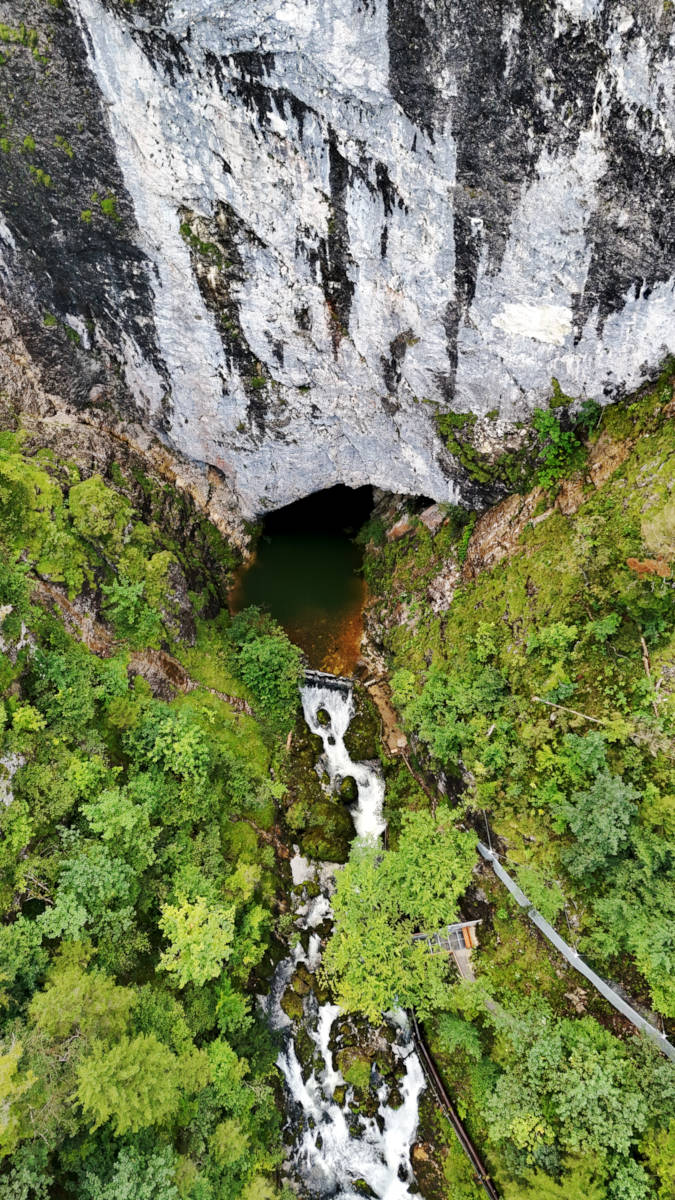
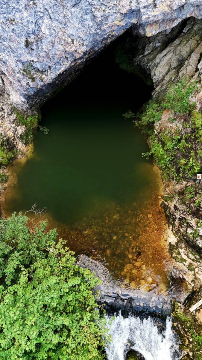
The spring is located at the foot of a 100-metre-high, quite spectacular limestone rock face. The water emerges from a deep cave with a triangular entrance and a steeply descending main passage. The width of the spring pond is relatively easy to determine at 30 metres, but measurements of the depth revealed 32 m, a rather meaningless number which was simply determined at the point where the part of the cave above the water level ends. In other words, the cave passage does not end at this point and continues steadily downwards, so this measured value has no significance whatsoever. However, it is still given as the depth of the spring. We know that after a narrow section, the main passage turns into a vertical shaft that descends to a depth of 80 metres. How the cave passage continues from there, however, is completely unknown. However, the depth of the spring is 80 m, not 23 m.
The spring is the end of a waterfilled cave system. This cave has been explored since 1962, but it became famous, or better infamous, in 1987 when a female cave diver died in the cave. During the rescue operation another diver, a 24-year-old police officer, died too. A second rescue diver had a decompression accident. Finally, the famous German cave diver Jochen Hasenmayer was called. He reached a depth of 80 m but could not discover of the dead female diver. As a result, the spring was closed for cave diving and was not explored any more.
The spring cave is closed until today, but since 1977 another part of the cave system is known. Right above the spring is another cave entrance, which leads to a small siphon. It was already researched in 1911 by Inspector Georg Lahner (Linz). The water was pumped out for the first time in 1977, and a cave passage of about 1,000 m was explored. This floor of the cave unfortunately has very strong height fluctuations and thus reaches the karst water level twice. The first time results in a cave lake that can be easily crossed. At its end, however, it has a siphon, which is currently the centre of exploration. It was first dived in 2002 by Robert Seebacher, who reached a depth of 32 metres.
The Pießling Ursprung is signposted on the main road in Roßleithen. However, the road is closed and you have to park on the main road in front of the Gasthof zum Sengschmied. From here, follow the tarmac road southwards, always upstream along the Pießling. The Pießling still has a considerable gradient here, which is why the energy of the water has been utilised for centuries and a whole series of water mills were built here. Finally, the trail ends at the spring with a viewing platform, which was renovated in 2024. The spring can be seen from here. Due to the depth of the water, it has a characteristic blue-green colour, especially in fine weather when the sunshine illuminates the water. This colour is a result of the high lime content in the water, through which all colours of the spectrum are filtered, but blue the least. The cave passage leading downwards is the reason why this spring is known in German as Tiefer Karst and in English as a Vaucluse-type karst spring.
There have been structural changes not only along the stream, but also at the spring pot. The spring was dammed up with a dam, so it is probably about 1 to 2 m higher than natural. However, the main reason for this dam was not to increase the height, but to collect the spring water for the nearby scythe factory. The pressure pipe, which runs along the footpath to the factory building, has a capacity of around 500 litres per second. As the factory is empty, today the water simply pours back into the stream in a spectacular waterfall. The path from the car park to the spring is now a themed trail on hydropower with various highlights and explanatory panels, a freely accessible open-air museum. Highlights include the Tupfhammer, the old manor house of the scythe works, the Schwanzhammer, where the largest scythe ever forged is on display, the Waldhammer, the bone mill called Knochenstampf, and finally the Stummer mill, which was actually used to grind grain. The stream has been modified to utilise water power since at least 1540. The hydropower trail is 1.2 km long, 30% of which is tarmac, the rest is gravel, with an ascent of 190 m to the source taking around 30 minutes.
The Waldhammer is probably the most unusual stop on this trail; built in 1886, scythes were spread, dressed and grey-hammered here. All these operations were carried out with the help of water power. In 1909, the pressure pipes and the power station were built, with two Francis spiral turbines supplying 416 kW of electricity. A polishing and levelling shop was added in 1912, followed by an extension in 1921 and a hardening shop in 1932. Scythe production only came to an end in 1992 when production was moved to the Zainhammer.
 Search DuckDuckGo for "Pießling Ursprung"
 Google Earth Placemark
 OpenStreetMap
 Pießling-Ursprung
  Pießling-Ursprung - Naturschutzbuch Detailansicht
  Index
Index Topics
 Hierarchical
 Countries
 Maps
Maps