Felsentor Unteremmendorf
Useful Information
| Location: |
Unteremmendorf 14, 85125 Kinding.
Parking in Untemmendorf, 150 m steep ascent, 10 minutes. Parking 700 m after leaving the village in the direction of Irlahüll, 700 m along the edge of the valley, 10 minutes. (48.9877848, 11.4347799) |
| Open: |
no restrictions. [2025] |
| Fee: |
free. [2025] |
| Classification: |
 Natural Bridge Natural Bridge
|
| Light: | bring torch |
| Dimension: | W=6 m, H=6 m. |
| Guided tours: | self guided |
| Photography: | allowed |
| Accessibility: | no |
| Bibliography: | |
| Address: |
Tourist-Information Kinding, Kipfenberger Straße 4, 85125 Kinding, Tel: +49-8467-8401-0.
E-mail: |
| As far as we know this information was accurate when it was published (see years in brackets), but may have changed since then. Please check rates and details directly with the companies in question if you need more recent info. |
|
History
| 1119 | The episcopal ministerial family is first mentioned with Konrad von Emmendorf. |
Description

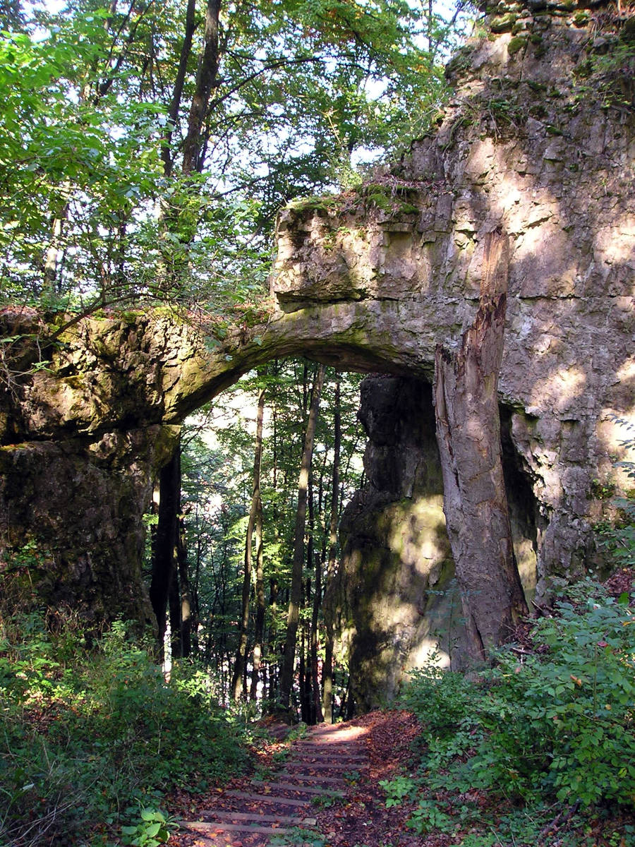
The Felsentor Unteremmendorf (Unteremmendorf rock gate) is a natural bridge which is actually a cave ruin, meaning that the rest of the cave has been destroyed by weathering. Only a small part of the cave roof still exists and forms the spectacular natural bridge. The cave was formed when the valley was much less deep, before the Urdonau cut into it and created the Altmühltal. Urdonau (ancient Danube) is the German term used for valleys which were formed by the Danube long ago, when it had a different course, and which is now the valley of a tributary. Before the Danube cut deep into the limestone, the surrounding area drained towards the Urdonau valley at the level of the natural bridge. Today’s gate was probably relatively close to the entrance of the former river cave, and a stream probably emerged from it.
This place is also known as Burgstall (Castle Rock) or Torfelsen (Gate Rock), probably because the natural bridge was the entrance to a castle that has now more or less disappeared. It was located on the rock east of the natural bridge. In addition to the natural bridge, a remnant of a cave, a 25 m long passage called Schmiedeloch or Östliches Schneiderloch, is also accessible. You have to climb up a short iron ladder to reach it. Further west there is a second cave, 15 metres long, called Westliches Schneiderloch. Both were part of the castle complex, and the natural bridge was a narrow, easily defended entrance to the castle complex. The castle was called Torfelsen (Gate Rock) and was one of three castles belonging to the Emmendorf family, a family of service men from Eichstätt. The other two were the Saufelsen (Pig Rock) and the Hubertusfelsen (Hubertus Rock), from all three of which you have a magnificent view of the Altmühlbogen (meander of the Altmühl river) between Beilngries and Kinding. At the natural bridge there is a plaque explaining the history and connections with the three castles of Emmendorf (only in German).
Over the course of time, the natural bridge has been regarded several times as the ruins of the castle, i.e. as an artificial structure. However, this is not the case; in fact, the natural bridge was created naturally and was merely utilised to the full within the castle.
 Search DuckDuckGo for "Felsentor Unteremmendorf"
 Google Earth Placemark
 OpenStreetMap
 Felsentor Unteremmendorf
  (visited: 18-FEB-2025)
 Index
Index Topics
 Hierarchical
 Countries
 Maps
Maps